IMAGES TAKEN NEAR TO
Chapel Lane, ROTHERHAM, S63 0HT
Introduction
This page details the photographs taken nearby to Chapel Lane, S63 0HT by members of the Geograph project.
The Geograph project started in 2005 with the aim of publishing, organising and preserving representative images for every square kilometre of Great Britain, Ireland and the Isle of Man.

There are currently over 7.5m images from over14,400 individuals and you can help contribute to the project by visiting https://www.geograph.org.uk
Image Map
Images are licensed for reuse under creativecommons.org/licenses/by-sa/2.0
Notes
- Clicking on the map will re-center to the selected point.
- The higher the marker number, the further away the image location is from the centre of the postcode.
Image Listing (15 Images Found)
Images are licensed for reuse under creativecommons.org/licenses/by-sa/2.0
Image
Details
Distance


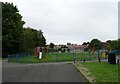
4
Corner of Playing Field in East Thurnscoe
Image: © Jonathan Clitheroe
Taken: 14 Sep 2016
0.10 miles
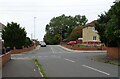
5

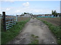
Block on Chapel Lane
Pedestrian access can be gained to the left. Fly-tipping is endemic around here and this block is designed to prevent some of it
Image: © Jonathan Thacker
Taken: 26 Apr 2018
0.10 miles
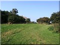
6
Entrance to allotments, Chapel Lane
Image: © Jonathan Thacker
Taken: 26 Apr 2018
0.11 miles