IMAGES TAKEN NEAR TO
Clayton Lane, ROTHERHAM, S63 0BG
Introduction
This page details the photographs taken nearby to Clayton Lane, S63 0BG by members of the Geograph project.
The Geograph project started in 2005 with the aim of publishing, organising and preserving representative images for every square kilometre of Great Britain, Ireland and the Isle of Man.

There are currently over 7.5m images from over14,400 individuals and you can help contribute to the project by visiting https://www.geograph.org.uk
Image Map
Images are licensed for reuse under creativecommons.org/licenses/by-sa/2.0
Notes
- Clicking on the map will re-center to the selected point.
- The higher the marker number, the further away the image location is from the centre of the postcode.
Image Listing (6 Images Found)
Images are licensed for reuse under creativecommons.org/licenses/by-sa/2.0
Image
Details
Distance
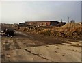
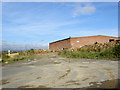
3
Warehouses
Storage units for a business called Ellerpack and built by Watfords of Wombwell.
Image: © Richard Spencer
Taken: 5 Feb 2006
0.16 miles
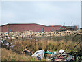
5
What was Ellerpack warehousing.
These buildings are incredibly exposed to the wind.
Image: © Steve Fareham
Taken: 20 Aug 2007
0.19 miles
6
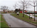
Gooseacre Primary School, Thurnscoe, Barnsley, South Yorkshire
Image: © Robert Neilson
Taken: 11 Feb 2007
0.19 miles