
IMAGES TAKEN NEAR TO
Langsett Crescent, SHEFFIELD, S6 2TU
Introduction
This page details the photographs taken nearby to Langsett Crescent, S6 2TU by members of the Geograph project.
The Geograph project started in 2005 with the aim of publishing, organising and preserving representative images for every square kilometre of Great Britain, Ireland and the Isle of Man.

There are currently over 7.5m images from over14,400 individuals and you can help contribute to the project by visiting https://www.geograph.org.uk
Image Map
Images are licensed for reuse under creativecommons.org/licenses/by-sa/2.0
Notes
- Clicking on the map will re-center to the selected point.
- The higher the marker number, the further away the image location is from the centre of the postcode.
Image Listing (188 Images Found)
Images are licensed for reuse under creativecommons.org/licenses/by-sa/2.0
Image
Details
Distance
1
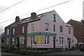
Dental Floss or Candy Floss, Langsett Road, Hillsborough, Sheffield
Hillsborough Family Dental Centre ... on Langsett Road, Hillsborough.
Image: © Terry Robinson
Taken: 10 Dec 2008
0.03 miles
4
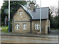
Old Toll House by Langsett Road, Sheffield
Langsett Road Toll House by the B6079 (was A616), in parish of Sheffield (Sheffield District), No. 329, Langsett Road, S6 2UP.
Surveyed
Milestone Society National ID: YS.SHE04
Image: © Alan Rosevear
Taken: 21 Sep 2012
0.05 miles
5
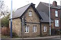
Toll House, Langsett Road, Hillsborough, Sheffield - 2
Image: © Terry Robinson
Taken: 10 Dec 2008
0.06 miles
6
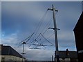
Supertram Overhead Power Lines, Hillsborough, Sheffield
Look up and see some wonderful configurations of Power Lines for the Sheffield Supertram System
Image: © Terry Robinson
Taken: 10 Dec 2008
0.06 miles
7
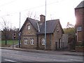
Toll House, Langsett Road, Hillsborough, Sheffield - 1
This small building was originally a Toll House when Langsett Road was used by Horses and Carts... now Sheffield Supertrams pass it every few minutes. Thankfully, as a listed building, it survived the road widening when the Supertrams were introduced. An old picture shows that the house had a large bay front to it - where the twin lower windows are - which would allow the Toll Keeper to see anything approaching from either direction. If you look closely you can see the outline of the 'V' shaped roof. The Victoria Hotel - later Victoria Vaults - public house was located very close to the left of the Toll House ... now it's open ground. Image
Image: © Terry Robinson
Taken: 10 Dec 2008
0.06 miles
8
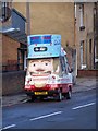
Sheffield's Uncle Sam, Burnaby Street, Sheffield
Couldn't resist this picture!
Image: © Terry Robinson
Taken: 10 Dec 2008
0.07 miles
10
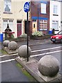
The Policeman's Balls ... Hammerton Road, Hillsborough, Sheffield
The Four Balls have been used to stop vehicles driving past the main corner entrance to Hammerton Road Police Station ... cycles can still pass through the middle and, of course, pedestrians can use the pavement. The terraced houses in the background are shown on the 1903 Ordnance Survey Map ... but the Police Station wasn't built for another 30 years or so. Image Image Image
Image: © Terry Robinson
Taken: 2 Nov 2008
0.09 miles