IMAGES TAKEN NEAR TO
Burnaby Court, SHEFFIELD, S6 2QY
Introduction
This page details the photographs taken nearby to Burnaby Court, S6 2QY by members of the Geograph project.
The Geograph project started in 2005 with the aim of publishing, organising and preserving representative images for every square kilometre of Great Britain, Ireland and the Isle of Man.

There are currently over 7.5m images from over14,400 individuals and you can help contribute to the project by visiting https://www.geograph.org.uk
Image Map
Images are licensed for reuse under creativecommons.org/licenses/by-sa/2.0
Notes
- Clicking on the map will re-center to the selected point.
- The higher the marker number, the further away the image location is from the centre of the postcode.
Image Listing (109 Images Found)
Images are licensed for reuse under creativecommons.org/licenses/by-sa/2.0
Image
Details
Distance
2
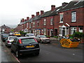
Walkley Senior School, Burnaby Crescent, Lower Walkley, Sheffield - 2012 View 1
Image: © Terry Robinson
Taken: 4 Sep 2012
0.09 miles
3
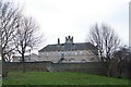
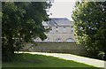
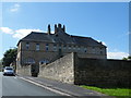
Walkley Senior School, Burnaby Crescent, Lower Walkley, Sheffield
This view has only been possible due to the demolition of the terraced housing that surrounded this fine building.
See also ...
Image
Image
Image
Image
For some 2012 views ... see ...
Image
Image
Image: © Terry Robinson
Taken: 10 Dec 2008
0.10 miles
4
Walkley Senior School, Burnaby Crescent, Lower Walkley, Sheffield - 2012 View 2
Image: © Terry Robinson
Taken: 4 Sep 2012
0.10 miles
5
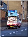
Sheffield's Uncle Sam, Burnaby Street, Sheffield
Couldn't resist this picture!
Image: © Terry Robinson
Taken: 10 Dec 2008
0.10 miles
6
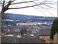
View from Walkley, Sheffield
Sheffield Wednesday's Hillsborough Stadium is on the left, The rear of Regent Court Apartment Block is in the centre, Bassett's Liquorice Allsorts factory is on the right (with the blue building). Image
Image: © Terry Robinson
Taken: 10 Dec 2008
0.11 miles
7
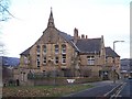
Walkley Senior School Building, Burnaby Crescent, Lower Walkley, Sheffield
This superb building was erected for the Sheffield School Board in 1874, for the senior pupils of the district. The primary school is lower down the hill on the right. It hasn't been used as a school for some years now, and, as far as I can ascertain, it is now Student accommodation for the University ... if you know differently please let me know. It was originally surrounded by terraced housing ... now mostly demolished and grassed over making it much more visible from the surrounding streets. It really is a superb building and well worth preserving. Image Image Image Image Image
Image: © Terry Robinson
Taken: 10 Dec 2008
0.11 miles
8
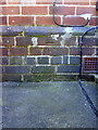
Benchmark at the junction of Nos. 73 and 75 Hammerton Road
Ordnance Survey cut mark benchmark described on the Bench Mark Database at http://www.bench-marks.org.uk/bm36724
Image: © Roger Templeman
Taken: 3 Feb 2011
0.11 miles
9
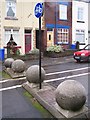
The Policeman's Balls ... Hammerton Road, Hillsborough, Sheffield
The Four Balls have been used to stop vehicles driving past the main corner entrance to Hammerton Road Police Station ... cycles can still pass through the middle and, of course, pedestrians can use the pavement. The terraced houses in the background are shown on the 1903 Ordnance Survey Map ... but the Police Station wasn't built for another 30 years or so. Image Image Image
Image: © Terry Robinson
Taken: 2 Nov 2008
0.12 miles
10
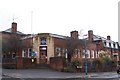
Hammerton Road Police Station, Hillsborough, Sheffield
Hammerton Road Police Station was built in the early 1930's but its 'claim to fame' came in 1981 ... when The Yorkshire Ripper, Peter Sutcliffe was arrested by two local policemen and taken back to Hammerton Road for questioning. Image Image Image
Image: © Terry Robinson
Taken: 2 Nov 2008
0.12 miles