IMAGES TAKEN NEAR TO
Carnaby Road, SHEFFIELD, S6 2NH
Introduction
This page details the photographs taken nearby to Carnaby Road, S6 2NH by members of the Geograph project.
The Geograph project started in 2005 with the aim of publishing, organising and preserving representative images for every square kilometre of Great Britain, Ireland and the Isle of Man.

There are currently over 7.5m images from over14,400 individuals and you can help contribute to the project by visiting https://www.geograph.org.uk
Image Map
Images are licensed for reuse under creativecommons.org/licenses/by-sa/2.0
Notes
- Clicking on the map will re-center to the selected point.
- The higher the marker number, the further away the image location is from the centre of the postcode.
Image Listing (115 Images Found)
Images are licensed for reuse under creativecommons.org/licenses/by-sa/2.0
Image
Details
Distance
1
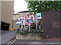
For Sale or To Let, near Stony Bank, Walkley
The number of signs here would put me off!
Image: © Terry Robinson
Taken: 3 May 2010
0.07 miles
2
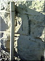
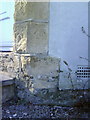
Benchmark on the roadside wall outside #151 Walkley Lane
Ordnance Survey cut mark benchmark described on the Bench Mark Database at http://www.bench-marks.org.uk/bm36736
Image: © Roger Templeman
Taken: 3 Feb 2011
0.07 miles
3
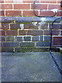
Benchmark at the junction of Nos. 73 and 75 Hammerton Road
Ordnance Survey cut mark benchmark described on the Bench Mark Database at http://www.bench-marks.org.uk/bm36724
Image: © Roger Templeman
Taken: 3 Feb 2011
0.08 miles
4

Benchmark on roadside wall of #189 Walkley Lane
Ordnance Survey cut mark benchmark described on the Bench Mark Database at http://www.bench-marks.org.uk/bm36737
Image: © Roger Templeman
Taken: 3 Feb 2011
0.09 miles
6
Benchmark on #103 Walkley Lane
Ordnance Survey cut mark benchmark described on the Bench Mark Database at http://www.bench-marks.org.uk/bm32673
Image: © Roger Templeman
Taken: 3 Feb 2011
0.10 miles
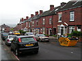
7
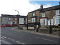
Bonnie and Clyde's
Former hairdressing business on Walkley Lane, Sheffield, which may have closed in a hail of bullets (for non-film buffs, it was a 1967 film about a couple who take to crime during the Great Depression in the USA and come to a sticky end).
Image: © Peter Barr
Taken: 12 Oct 2010
0.11 miles
8
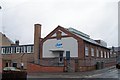
'Old' Crown Labels, Dodd Street, Hillsborough, Sheffield
This original building has the date 1913 proudly featured on the gable end, so this Hillsborough Company should already be making plans for a Centenary Celebration in another 5 years. Hammerton Road Police Station is opposite this building, but that was built in the 1930s. The extension on the left looks to be 1960s ... such extensions never did look as good as the original, did they? Image Image
Image: © Terry Robinson
Taken: 2 Nov 2008
0.11 miles
9
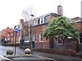
Hammerton Road Police Station, Hillsborough ... A Bit More
This part of the Police Station ... to the left of the main building ... looks to have been where the Police Cars were garaged through the archway. Now many police vehicles, of all sizes and descriptions are parked in a big yard to the rear of the site. Image Image Image
Image: © Terry Robinson
Taken: 2 Nov 2008
0.12 miles
10
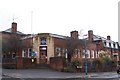
Hammerton Road Police Station, Hillsborough, Sheffield
Hammerton Road Police Station was built in the early 1930's but its 'claim to fame' came in 1981 ... when The Yorkshire Ripper, Peter Sutcliffe was arrested by two local policemen and taken back to Hammerton Road for questioning. Image Image Image
Image: © Terry Robinson
Taken: 2 Nov 2008
0.12 miles