IMAGES TAKEN NEAR TO
Carrwell Lane, SHEFFIELD, S6 1NR
Introduction
This page details the photographs taken nearby to Carrwell Lane, S6 1NR by members of the Geograph project.
The Geograph project started in 2005 with the aim of publishing, organising and preserving representative images for every square kilometre of Great Britain, Ireland and the Isle of Man.

There are currently over 7.5m images from over14,400 individuals and you can help contribute to the project by visiting https://www.geograph.org.uk
Image Map
Images are licensed for reuse under creativecommons.org/licenses/by-sa/2.0
Notes
- Clicking on the map will re-center to the selected point.
- The higher the marker number, the further away the image location is from the centre of the postcode.
Image Listing (50 Images Found)
Images are licensed for reuse under creativecommons.org/licenses/by-sa/2.0
Image
Details
Distance
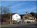
2
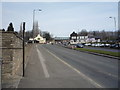
Penistone Road North (A61), Wadsley Bridge
Looking north east.
Image: © JThomas
Taken: 12 Mar 2016
0.04 miles
4
Wadsley Bridge - The Railway
On Penistone Road.
Image: © Dave Bevis
Taken: 5 Aug 2011
0.06 miles
5
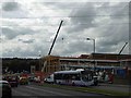
Construction of Sainsbury's supermarket at Wadsley Bridge
Image: © Steve Fareham
Taken: 27 Aug 2014
0.06 miles
6
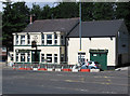
Wadsley Bridge - The New Inn
On Penistone Road.
Image: © Dave Bevis
Taken: 5 Aug 2011
0.06 miles
7
Wadsley Bridge - Carrs Stainless Steels
On Penistone Road.
Image: © Dave Bevis
Taken: 5 Aug 2011
0.06 miles
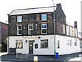
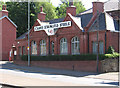
8
The Railway public house, Wadsley Bridge
On Penistone Road North (A61).
Image: © JThomas
Taken: 12 Mar 2016
0.07 miles
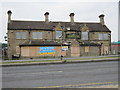
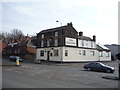
9
Two closed pubs
On the A61 Penistone Road near Hillsborough football stadium.
Image: © Graham Hogg
Taken: 1 Mar 2012
0.07 miles
10
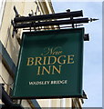
Sign for the New Bridge Inn, Wadsley Bridge
Image: © JThomas
Taken: 12 Mar 2016
0.07 miles