IMAGES TAKEN NEAR TO
Maryhill Close, ROTHERHAM, S60 5UT
Introduction
This page details the photographs taken nearby to Maryhill Close, S60 5UT by members of the Geograph project.
The Geograph project started in 2005 with the aim of publishing, organising and preserving representative images for every square kilometre of Great Britain, Ireland and the Isle of Man.

There are currently over 7.5m images from over14,400 individuals and you can help contribute to the project by visiting https://www.geograph.org.uk
Image Map
Images are licensed for reuse under creativecommons.org/licenses/by-sa/2.0
Notes
- Clicking on the map will re-center to the selected point.
- The higher the marker number, the further away the image location is from the centre of the postcode.
Image Listing (6 Images Found)
Images are licensed for reuse under creativecommons.org/licenses/by-sa/2.0
Image
Details
Distance
1
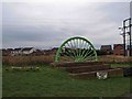
Mining Wheel marker into Treeton
The log on the left hand side marks the entrance road to South Yorkshire Boat and Ski Club.
Image: © Steve Fareham
Taken: 11 Jan 2009
0.13 miles
2
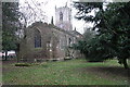
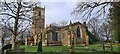
St Helen's Church
The Church in Treeton is dedicated to St Helen.
Image: © Michael Patterson
Taken: 3 Feb 2006
0.16 miles
4
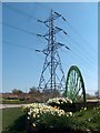
Pit-head wheel and daffodils with pylon at eastern edge of Treeton village
Considering Treeton's proud coal-mining past, it is quite amazing how little evidence of that heritage is visible today.
Image: © Neil Theasby
Taken: 17 Apr 2010
0.21 miles
5
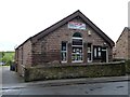
Treeton Reading Room
The Reading Room was erected in 1888 as a parish room and Sunday School.
Image: © Graham Hogg
Taken: 31 May 2012
0.22 miles