IMAGES TAKEN NEAR TO
Highfield View, ROTHERHAM, S60 5SA
Introduction
This page details the photographs taken nearby to Highfield View, S60 5SA by members of the Geograph project.
The Geograph project started in 2005 with the aim of publishing, organising and preserving representative images for every square kilometre of Great Britain, Ireland and the Isle of Man.

There are currently over 7.5m images from over14,400 individuals and you can help contribute to the project by visiting https://www.geograph.org.uk
Image Map
Images are licensed for reuse under creativecommons.org/licenses/by-sa/2.0
Notes
- Clicking on the map will re-center to the selected point.
- The higher the marker number, the further away the image location is from the centre of the postcode.
Image Listing (6 Images Found)
Images are licensed for reuse under creativecommons.org/licenses/by-sa/2.0
Image
Details
Distance
5
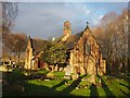
Church of St Mary, Catcliffe
The church was built in 1910 and is one of five churches in the Rivers Team within the diocese of Sheffield, one parish covering the five communities of Brinsworth, Catcliffe, Treeton, Tinsley and Waverley.
Image: © Graham Hogg
Taken: 4 Jan 2021
0.24 miles
