IMAGES TAKEN NEAR TO
Spa Well Crescent, ROTHERHAM, S60 5RD
Introduction
This page details the photographs taken nearby to Spa Well Crescent, S60 5RD by members of the Geograph project.
The Geograph project started in 2005 with the aim of publishing, organising and preserving representative images for every square kilometre of Great Britain, Ireland and the Isle of Man.

There are currently over 7.5m images from over14,400 individuals and you can help contribute to the project by visiting https://www.geograph.org.uk
Image Map
Images are licensed for reuse under creativecommons.org/licenses/by-sa/2.0
Notes
- Clicking on the map will re-center to the selected point.
- The higher the marker number, the further away the image location is from the centre of the postcode.
Image Listing (9 Images Found)
Images are licensed for reuse under creativecommons.org/licenses/by-sa/2.0
Image
Details
Distance
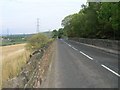
2
Rotherham Roundwalk at Spa Hill, north of Treeton
Image: © John Slater
Taken: 22 Oct 2014
0.18 miles
3
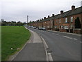
Treeton Terrace
This row of terraced houses in Treeton were probably built for the once nearby coal mine.
Image: © Michael Patterson
Taken: 2 May 2006
0.20 miles
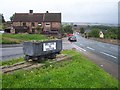
7
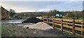
New fencing by Old Flatts Farm
For diversionary footpath
Image: © Chris Morgan
Taken: 4 Jan 2021
0.23 miles
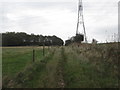
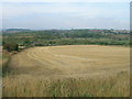
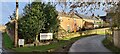
8
Old Flatts Farm, Treeton
Part harvested oil seed rape by Bole Hill, Treeton.
Image: © Martin Speck
Taken: 26 Jul 2009
0.23 miles
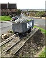
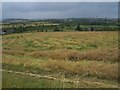
9
Old Flatts Farm
A pets and equine crematorium
Image: © Chris Morgan
Taken: 4 Jan 2021
0.24 miles