IMAGES TAKEN NEAR TO
Normanville Avenue, ROTHERHAM, S60 5AH
Introduction
This page details the photographs taken nearby to Normanville Avenue, S60 5AH by members of the Geograph project.
The Geograph project started in 2005 with the aim of publishing, organising and preserving representative images for every square kilometre of Great Britain, Ireland and the Isle of Man.

There are currently over 7.5m images from over14,400 individuals and you can help contribute to the project by visiting https://www.geograph.org.uk
Image Map
Images are licensed for reuse under creativecommons.org/licenses/by-sa/2.0
Notes
- Clicking on the map will re-center to the selected point.
- The higher the marker number, the further away the image location is from the centre of the postcode.
Image Listing (5 Images Found)
Images are licensed for reuse under creativecommons.org/licenses/by-sa/2.0
Image
Details
Distance
2
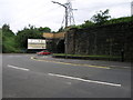
Bundle It Bridge
The advert from ntl encourages us to bundle all our electronic communications into one package. The railway bridge on the other hand carries an older form of communication over the A631 in Brinsworth.
Image: © Michael Patterson
Taken: 26 Jun 2006
0.23 miles

5
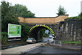
Low Bridge on the A631
So low that many vehicles have to drive in the middle of the road to get under it.
Image: © Graham Hogg
Taken: 31 Jul 2013
0.25 miles