IMAGES TAKEN NEAR TO
Grange Lane, ROTHERHAM, S60 5AE
Introduction
This page details the photographs taken nearby to Grange Lane, S60 5AE by members of the Geograph project.
The Geograph project started in 2005 with the aim of publishing, organising and preserving representative images for every square kilometre of Great Britain, Ireland and the Isle of Man.

There are currently over 7.5m images from over14,400 individuals and you can help contribute to the project by visiting https://www.geograph.org.uk
Image Map (Loading...)


Getting Data...Please wait
Leaflet Map data © OpenStreetMap
Images are licensed for reuse under creativecommons.org/licenses/by-sa/2.0
Notes
- Clicking on the map will re-center to the selected point.
- The higher the marker number, the further away the image location is from the centre of the postcode.
Image Listing (2 Images Found)
Images are licensed for reuse under creativecommons.org/licenses/by-sa/2.0
Image
Details
Distance
1
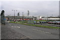
Gas Production Site
The BOC gas production site in Brinsworth produces oxygen which is distributed to the Rotherham and Sheffield steelworks through a mains pipeline. The two towers are air separation units.
Image: © Michael Patterson
Taken: 13 Feb 2006
0.11 miles
2
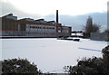
Corus in the snow
Steel making took up huge areas in Sheffield, offering employment and a way of life for many. I doubt we will see its like again.
Image: © Nic Franklin-Woolley
Taken: 21 Feb 2010
0.24 miles