IMAGES TAKEN NEAR TO
Knutton Crescent, SHEFFIELD, S5 9NW
Introduction
This page details the photographs taken nearby to Knutton Crescent, S5 9NW by members of the Geograph project.
The Geograph project started in 2005 with the aim of publishing, organising and preserving representative images for every square kilometre of Great Britain, Ireland and the Isle of Man.

There are currently over 7.5m images from over14,400 individuals and you can help contribute to the project by visiting https://www.geograph.org.uk
Image Map
Images are licensed for reuse under creativecommons.org/licenses/by-sa/2.0
Notes
- Clicking on the map will re-center to the selected point.
- The higher the marker number, the further away the image location is from the centre of the postcode.
Image Listing (21 Images Found)
Images are licensed for reuse under creativecommons.org/licenses/by-sa/2.0
Image
Details
Distance
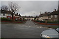
1
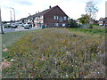
Shops on Chaucer Road, Parson Cross
Splendid planting of wild flower meadow.
Image: © Peter Barr
Taken: 5 Oct 2011
0.08 miles
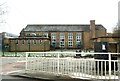
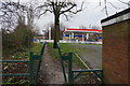
2

Mansell Primary School
School on the B6087 Chaucer Road, at the intersection with Mansell Crescent
Image: © Roger May
Taken: 22 Apr 2006
0.10 miles
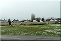
7
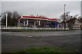
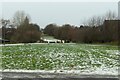
Parson Cross Filling Station, Wordsworth Avenue
Image: © Ian S
Taken: 17 Dec 2014
0.18 miles
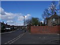
10
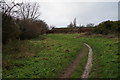
Trans Pennine Trail towards Wordsworth Avenue
Image: © Ian S
Taken: 17 Dec 2014
0.20 miles