IMAGES TAKEN NEAR TO
Holgate Road, SHEFFIELD, S5 9LH
Introduction
This page details the photographs taken nearby to Holgate Road, S5 9LH by members of the Geograph project.
The Geograph project started in 2005 with the aim of publishing, organising and preserving representative images for every square kilometre of Great Britain, Ireland and the Isle of Man.

There are currently over 7.5m images from over14,400 individuals and you can help contribute to the project by visiting https://www.geograph.org.uk
Image Map (Loading...)


Getting Data...Please wait
Leaflet Map data © OpenStreetMap
Images are licensed for reuse under creativecommons.org/licenses/by-sa/2.0
Notes
- Clicking on the map will re-center to the selected point.
- The higher the marker number, the further away the image location is from the centre of the postcode.
Image Listing (14 Images Found)
Images are licensed for reuse under creativecommons.org/licenses/by-sa/2.0
Image
Details
Distance
1
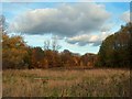
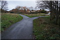
View of "The Brook", Parson Cross Estate
Although most Sheffield people view Parson Cross as a sprawling, grim and troubled council estate, there is beauty here. My picture could just as easily have been taken in Windsor Great Park.
Image: © Neil Theasby
Taken: 6 Nov 2010
0.09 miles
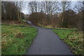
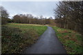
10
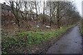
Trans Pennine Trail rear of Deerlands Avenue
Image: © Ian S
Taken: 17 Dec 2014
0.19 miles