IMAGES TAKEN NEAR TO
Turie Avenue, SHEFFIELD, S5 9JA
Introduction
This page details the photographs taken nearby to Turie Avenue, S5 9JA by members of the Geograph project.
The Geograph project started in 2005 with the aim of publishing, organising and preserving representative images for every square kilometre of Great Britain, Ireland and the Isle of Man.

There are currently over 7.5m images from over14,400 individuals and you can help contribute to the project by visiting https://www.geograph.org.uk
Image Map (Loading...)


Getting Data...Please wait
Leaflet Map data © OpenStreetMap
Images are licensed for reuse under creativecommons.org/licenses/by-sa/2.0
Notes
- Clicking on the map will re-center to the selected point.
- The higher the marker number, the further away the image location is from the centre of the postcode.
Image Listing (21 Images Found)
Images are licensed for reuse under creativecommons.org/licenses/by-sa/2.0
Image
Details
Distance
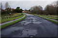
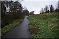
1
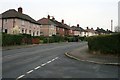
Colley Road
From the end of Turie Avenue. A scene typical of the 1930's council estates all around Sheffield.
Image: © David Lally
Taken: 18 Nov 2010
0.05 miles
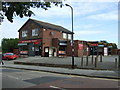
2
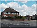
Colley Avenue's junction with Rokeby Road, Parson Cross Estate
Image: © Neil Theasby
Taken: 25 Aug 2011
0.07 miles
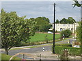
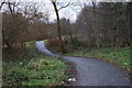
10
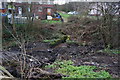
Trans Pennine Trail at Tongue Gutter, Parson Cross
Image: © Ian S
Taken: 17 Dec 2014
0.22 miles