IMAGES TAKEN NEAR TO
Shirecliffe Road, SHEFFIELD, S5 8XB
Introduction
This page details the photographs taken nearby to Shirecliffe Road, S5 8XB by members of the Geograph project.
The Geograph project started in 2005 with the aim of publishing, organising and preserving representative images for every square kilometre of Great Britain, Ireland and the Isle of Man.

There are currently over 7.5m images from over14,400 individuals and you can help contribute to the project by visiting https://www.geograph.org.uk
Image Map (Loading...)


Getting Data...Please wait
Leaflet Map data © OpenStreetMap
Images are licensed for reuse under creativecommons.org/licenses/by-sa/2.0
Notes
- Clicking on the map will re-center to the selected point.
- The higher the marker number, the further away the image location is from the centre of the postcode.
Image Listing (9 Images Found)
Images are licensed for reuse under creativecommons.org/licenses/by-sa/2.0
Image
Details
Distance
1
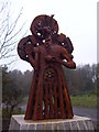
The Parkwood Deer
Jason Thomson's Parkwood Deer sculpture on Shirecliffe Road. The sculpture was officially installed on 11 December 2011, after this picture was taken.
Image: © Martin Speck
Taken: 13 Nov 2011
0.04 miles
2
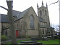
Christ Church, Pitsmoor
On Pitsmoor Road in Sheffield.
Image: © Tony Smith
Taken: 5 Dec 2004
0.14 miles
3

Anti-aircraft gun site at Parkwood
I once lived next-door to a Mr Fred Sharman. He spent some time manning the anti-aircraft gun on Shirecliffe Hill during the Second World War. I am told that this is the foundation for the gun mounting. Also see Image
Image: © Martin Speck
Taken: 9 Sep 2007
0.18 miles
4

Anti-aircraft gun site detail
Detailed view of the foundations of the WWII gun site above Parkwood Springs.
Image: © Martin Speck
Taken: 9 Sep 2007
0.18 miles
5
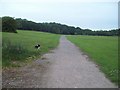
Path and Playing Field at Parkwood Springs
Image: © Jonathan Clitheroe
Taken: 4 Jun 2011
0.19 miles
6
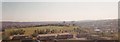
Parkwood College car park
This photograph was taken in the Spring of 1998 from the top floor of Parkwood College, part of the Sheffield College. Until 1988 the College was known as Shirecliffe College. The College closed in the summer of 1998. The buildings in the foreground are 'temporary' classrooms which were in use from the time of their erection until the closure of the College. In the distance Sheffield University Arts Tower and the Royal Hallamshire Hospital can both be clearly seen. The College site is now a development of 3/4 bedroom houses. This image has been scanned from the original photograph.
Image: © Dave Pickersgill
Taken: 1 Apr 1998
0.21 miles
7

Standish Bank
Modern housing in the Shirecliffe district of Sheffield.
Image: © Graham Hogg
Taken: 1 Mar 2012
0.22 miles
8
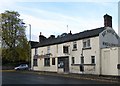
Bay Horse Inn
Pitsmoor Road, Pitsmoor, Sheffield.
Image: © David Rogers
Taken: 26 Oct 2009
0.23 miles
9
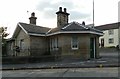
Old Toll House by Burngreave Road, Sheffield
Pitsmoor bar by the A6135 (was A61), in parish of Sheffield (Sheffield District), Toll Bar Cottage, No. 189, Burngreave Road, S3 9DL.
Grade II listed.
List Entry Number: 1246983 https://historicengland.org.uk/listing/the-list/list-entry/1246983
Surveyed
Milestone Society National ID: YS.SHE01
Image: © Alan Rosevear
Taken: 22 Sep 2012
0.25 miles