IMAGES TAKEN NEAR TO
Penrith Crescent, SHEFFIELD, S5 8TX
Introduction
This page details the photographs taken nearby to Penrith Crescent, S5 8TX by members of the Geograph project.
The Geograph project started in 2005 with the aim of publishing, organising and preserving representative images for every square kilometre of Great Britain, Ireland and the Isle of Man.

There are currently over 7.5m images from over14,400 individuals and you can help contribute to the project by visiting https://www.geograph.org.uk
Image Map (Loading...)


Getting Data...Please wait
Leaflet Map data © OpenStreetMap
Images are licensed for reuse under creativecommons.org/licenses/by-sa/2.0
Notes
- Clicking on the map will re-center to the selected point.
- The higher the marker number, the further away the image location is from the centre of the postcode.
Image Listing (19 Images Found)
Images are licensed for reuse under creativecommons.org/licenses/by-sa/2.0
Image
Details
Distance
1
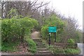
Scraith Wood, Herries Road, Sheffield
Scraith ... originally Scyrrh ... indicates that this wood grew on a Scree Slope.
Image: © Terry Robinson
Taken: 10 Apr 2008
0.15 miles
2
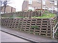
1960's Dry Stone Walling, Scraith Wood Drive, Sheffield
Looked awful when it was first used ... and some 40 years later doesn't look any better! Mind you if it had been built in brick it would probably have been covered in graffiti ... every cloud etc.
Image: © Terry Robinson
Taken: 10 Apr 2008
0.16 miles
3
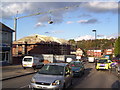
Building site on Teynham Road
Building the Herries Lodge Care Home on the site of the Five Arches Public House. See David Lally's picture Image taken from a different location.
Image: © Martin Speck
Taken: 26 Oct 2011
0.17 miles
4
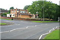
The Five Arches
Named after the nearby railway viaduct (Image) this estate pub on Herris Road is now closed and boarded-up.
Image: © David Lally
Taken: 25 Aug 2008
0.18 miles
5
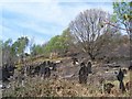
Wardsend Cemetery
The disused cemetery at Wardsend after a grass fire.
Image: © Martin Speck
Taken: 21 Apr 2009
0.18 miles
6
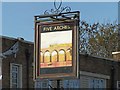
Five Arches Pub Sign, Herries Road, Sheffield
Image: © Terry Robinson
Taken: 16 Nov 2008
0.18 miles
7
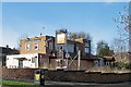
Five Arches Pub, Herries Road, Sheffield
Named after the Wardsend Viaduct further down Herries Road ... this pub from the 1960's is now closed and awaiting development or refurbishment. I remember visiting this pub many times with colleagues from the nearby Bassett's Factory and Offices and it was a good venue for lunchtime or evening get-togethers or leaving do's. Image Image
Image: © Terry Robinson
Taken: 16 Nov 2008
0.19 miles
8
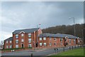
Apartment Block, Herries Road, Sheffield
This site was originally a Petrol Station ... never thought it would look this good, or be able to have so many apartments in the space.
Image: © Terry Robinson
Taken: 10 Apr 2008
0.21 miles
9
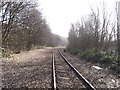
Railway Line, Sheffield
View of the Woodhead Railway Line from Wardsend Cemetery, Sheffield.
Image: © Nick Morris
Taken: 14 Mar 2014
0.21 miles
10
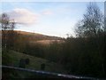
View from the Railway Bridge in Wardsend Cemetery
Victorian cemetery with the rare distinction of having a functional railway line running through the site. Some victims of the Sheffield Flood of 1864 are buried here although there have been no internments since the 1970s and the church is demolished.
Image: © Jonathan Clitheroe
Taken: 8 Apr 2009
0.22 miles