IMAGES TAKEN NEAR TO
Oxspring Bank, SHEFFIELD, S5 8NR
Introduction
This page details the photographs taken nearby to Oxspring Bank, S5 8NR by members of the Geograph project.
The Geograph project started in 2005 with the aim of publishing, organising and preserving representative images for every square kilometre of Great Britain, Ireland and the Isle of Man.

There are currently over 7.5m images from over14,400 individuals and you can help contribute to the project by visiting https://www.geograph.org.uk
Image Map
Images are licensed for reuse under creativecommons.org/licenses/by-sa/2.0
Notes
- Clicking on the map will re-center to the selected point.
- The higher the marker number, the further away the image location is from the centre of the postcode.
Image Listing (18 Images Found)
Images are licensed for reuse under creativecommons.org/licenses/by-sa/2.0
Image
Details
Distance
1
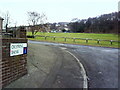
Junction of Oxspring Bank and Cookson Road
Image: © Roger Templeman
Taken: 2 Feb 2011
0.09 miles
2
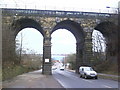
Railway viaduct MAC3-119 over Herries Road (A6102)
Sheffield Wednesday's Hillsborough Stadium visible through the central arch.
Image: © Roger Templeman
Taken: 2 Feb 2011
0.11 miles
3
Railway bridge over Herries Road, Sheffield
Beyond the bridge is the football stadium for Sheffield Wednesday FC.
Image: © Steve Fareham
Taken: 7 Jun 2009
0.11 miles
4
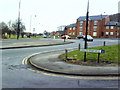
View from beside houses on Cookson Road towards Wordsworth Avenue
Image: © Roger Templeman
Taken: 2 Feb 2011
0.12 miles
5
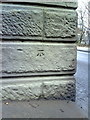
Benchmark on railway bridge over Herries Road
Ordnance Survey cut mark benchmark described on the Bench Mark Database at http://www.bench-marks.org.uk/bm23031
Image: © Roger Templeman
Taken: 2 Feb 2011
0.12 miles
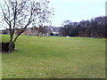
6
View from Scraith Wood Drive across Herries Road to Wordsworth Avenue
Image: © Roger Templeman
Taken: 2 Feb 2011
0.12 miles
7
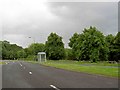
Bus stop near the junction of Wordsworth Ave. with Herries Road
Image: © Steve Fareham
Taken: 7 Jun 2009
0.13 miles
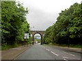
8
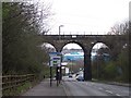
Five Arches Viaduct, Herries Road, Sheffield
Looking down Herries Road towards the Sheffield Wednesday Football Ground.
Image: © Terry Robinson
Taken: 10 Apr 2008
0.13 miles
9
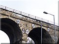
Graffiti on Wardsend Viaduct.
How do they do it? Why do they do it? Does anybody know who Joanne and Boncho are? These graffiti have been there so long they must be collecting their pensions by now.
Image: © Terry Robinson
Taken: 10 Apr 2008
0.13 miles
10
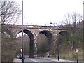
Wardsend Viaduct, Herries Road, Sheffield
View showing four of the five arches which gives this railway viaduct its alternative name. The viaduct was built by the Sheffield, Ashton-Under-Lyne and Manchester Railway, (later Manchester, Sheffield and Lincolnshire), to take its line over the Scraith Wood Valley. Opened in 1845 with the last regular passenger train crossing in 1983. Herries Road was built, using one of the arches, in 1920. Image
Image: © Terry Robinson
Taken: 10 Apr 2008
0.14 miles