IMAGES TAKEN NEAR TO
S5 8DA
Introduction
This page details the photographs taken nearby to S5 8DA by members of the Geograph project.
The Geograph project started in 2005 with the aim of publishing, organising and preserving representative images for every square kilometre of Great Britain, Ireland and the Isle of Man.

There are currently over 7.5m images from over14,400 individuals and you can help contribute to the project by visiting https://www.geograph.org.uk
Image Map
Images are licensed for reuse under creativecommons.org/licenses/by-sa/2.0
Notes
- Clicking on the map will re-center to the selected point.
- The higher the marker number, the further away the image location is from the centre of the postcode.
Image Listing (5 Images Found)
Images are licensed for reuse under creativecommons.org/licenses/by-sa/2.0
Image
Details
Distance
1
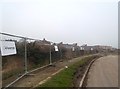
Houses under Construction near Parson Cross Park
Pictured here from Symons Crescent.
Image: © Jonathan Clitheroe
Taken: 12 Mar 2014
0.14 miles
2
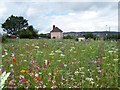
City meadows near Collinson Rd
Land near Collinson Rd, seeded with wild flowers. Much of the social housing in this part of Sheffield has been demolished and has been given over to meadows. Developed by Professor Nigel Dunnett of the University of Sheffield these City Centre meadows, designed to attract pollinating insects are now a decade old. It is planned to use similar planting techniques in the 2012 Olympic Park in London. A mixture of native and foreign species are chosen to provide colour and a source of pollen throughout the season.
Image: © Martin Speck
Taken: 17 Jul 2007
0.14 miles
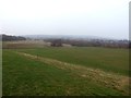
4
Rebuilt terrace on Southey Hill
A rebuilt terrace on Southey Hill as seen from the footpath to Kyle Crescent. On 12th March 1941 a German bomber, bound for the shipyards at Belfast was intercepted by an RAF fighter. In an effort to evade the British aircraft the German aircrew ditched their bomb, a massive anti-shipping mine. The terrace seen in the centre of this picture was completely destroyed. The building to the right, number 35 Southey Hill also sustained substantial damage. The children living at number 35 were evacuated to Cwmcarn where they lived with relatives. Picture Sheffield has a photograph of the damage. See http://picturesheffield.com/frontend.php?keywords=Ref_No_increment;EQUALS;s01084&pos=1&action=zoom&id=4906
Image: © Martin Speck
Taken: 22 Aug 2010
0.24 miles
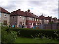
5
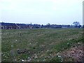
Common Land in Parson Cross
New-builds on Buchanan Crescent can be seen beyond the rough grass.
Image: © Jonathan Clitheroe
Taken: 14 Feb 2017
0.25 miles