IMAGES TAKEN NEAR TO
Hereward Road, SHEFFIELD, S5 7UB
Introduction
This page details the photographs taken nearby to Hereward Road, S5 7UB by members of the Geograph project.
The Geograph project started in 2005 with the aim of publishing, organising and preserving representative images for every square kilometre of Great Britain, Ireland and the Isle of Man.

There are currently over 7.5m images from over14,400 individuals and you can help contribute to the project by visiting https://www.geograph.org.uk
Image Map (Loading...)


Getting Data...Please wait
Leaflet Map data © OpenStreetMap
Images are licensed for reuse under creativecommons.org/licenses/by-sa/2.0
Notes
- Clicking on the map will re-center to the selected point.
- The higher the marker number, the further away the image location is from the centre of the postcode.
Image Listing (13 Images Found)
Images are licensed for reuse under creativecommons.org/licenses/by-sa/2.0
Image
Details
Distance
1
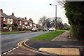
Elm Lane
Looking away from Sheffield Lane Top towards Southey Green.
Image: © David Lally
Taken: 18 Nov 2010
0.11 miles
2
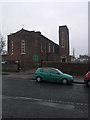
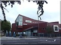
St Patrick's
St Patrick's RC Church stand at the northern edge of this square.
Image: © Michael Patterson
Taken: 18 Dec 2006
0.15 miles
3
St Patrick's RC Primary School
I will say no more about this lest it compromise one of my security questions.
Image: © David Lally
Taken: 18 Nov 2010
0.20 miles
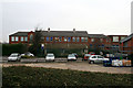
5
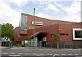
Longley Park 6th form college
Near Sheffield Lane Top.
Image: © Steve Fareham
Taken: 16 Aug 2008
0.21 miles
6
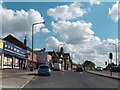
View towards "The Pheasant", Sheffield Lane Top
Image: © Neil Theasby
Taken: 25 Aug 2011
0.21 miles
7
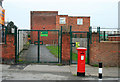
Entrance to St Patrick's RC School
Except for the higher security gates this entrance does not look that different from when I first entered in 1963.
Image: © David Lally
Taken: 18 Nov 2010
0.22 miles
8
Longley Park Sixth Form College
A further eduction college in north Sheffield opened in 2004 and built on the site of Firth Park Grammar School.
Image: © Graham Hogg
Taken: 14 Aug 2012
0.22 miles
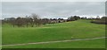
9
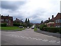
Masters Rd
Masters Rd showing 1930's social housing typical of this area.
Image: © Martin Speck
Taken: 20 Jul 2007
0.22 miles
10
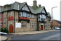
The Pheasant Inn
A prominent crossroads pub at Sheffield Lane Top.
This is a curious name for the area as, although it is a hill top and the highest point for some distance, there is no "Sheffield Lane" around, perhaps there was in the past?
Image: © David Lally
Taken: 18 Nov 2010
0.22 miles