IMAGES TAKEN NEAR TO
Fairbank Road, SHEFFIELD, S5 7DE
Introduction
This page details the photographs taken nearby to Fairbank Road, S5 7DE by members of the Geograph project.
The Geograph project started in 2005 with the aim of publishing, organising and preserving representative images for every square kilometre of Great Britain, Ireland and the Isle of Man.

There are currently over 7.5m images from over14,400 individuals and you can help contribute to the project by visiting https://www.geograph.org.uk
Image Map (Loading...)


Getting Data...Please wait
Leaflet Map data © OpenStreetMap
Images are licensed for reuse under creativecommons.org/licenses/by-sa/2.0
Notes
- Clicking on the map will re-center to the selected point.
- The higher the marker number, the further away the image location is from the centre of the postcode.
Image Listing (12 Images Found)
Images are licensed for reuse under creativecommons.org/licenses/by-sa/2.0
Image
Details
Distance
1

Houses on Longley Avenue West, Shirecliffe
Image: © Neil Theasby
Taken: 15 Sep 2011
0.12 miles
2
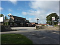
Devonshire Arms
Pub on Herries Road, Shirecliffe, Sheffield.
Image: © Peter Barr
Taken: 5 Oct 2011
0.12 miles
3
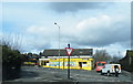
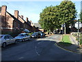
Shops on Herries Road, Longley, Sheffield - 1
Unbelievably this building has been in existence since 1575 when it was a row of cottages in the middle of nowhere ... these were known as Piper Cottages and Herries Road was Piper Lane. Nearby there is a Piper Road which reflects the areas original lanes and roads.
The road in the foreground is Norwood Avenue and across the road is Longley Lane.
See also ...
Image
Image: © Terry Robinson
Taken: 10 Mar 2013
0.15 miles
4
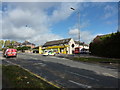
Shops on Herries Road, Longley, Sheffield - 2
For more information ... see ...
Image
Image: © Terry Robinson
Taken: 10 Mar 2013
0.15 miles
5
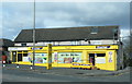
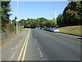
Police car and 87 bus outside yellow painted shop on Herries Road
At junction with Longley Lane.
Image: © Peter Barr
Taken: 5 Oct 2011
0.16 miles
6
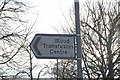
Blood Transfusion Service, Longley Lane, Sheffield
It is many years since the National Blood Service was known as the Blood Transfusion Centre ... but this sign on Herries Road still points the way ... and the general public still know what it mean! Image
Image: © Terry Robinson
Taken: 30 Nov 2008
0.17 miles
9

The Devonshire Arms, Shirecliffe
On Herries Road.
Image: © JThomas
Taken: 27 Sep 2014
0.21 miles
10
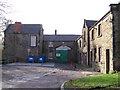
Norwood Grange Outbuildings, Sheffield
These outbuildings (stables?) look ripe for development but have been like this for some years. If they could be developed to match the Grange the whole area would benefit. Image
Image: © Terry Robinson
Taken: 16 Nov 2008
0.22 miles