IMAGES TAKEN NEAR TO
Fairbank Road, SHEFFIELD, S5 7DA
Introduction
This page details the photographs taken nearby to Fairbank Road, S5 7DA by members of the Geograph project.
The Geograph project started in 2005 with the aim of publishing, organising and preserving representative images for every square kilometre of Great Britain, Ireland and the Isle of Man.

There are currently over 7.5m images from over14,400 individuals and you can help contribute to the project by visiting https://www.geograph.org.uk
Image Map
Images are licensed for reuse under creativecommons.org/licenses/by-sa/2.0
Notes
- Clicking on the map will re-center to the selected point.
- The higher the marker number, the further away the image location is from the centre of the postcode.
Image Listing (39 Images Found)
Images are licensed for reuse under creativecommons.org/licenses/by-sa/2.0
Image
Details
Distance
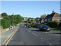
4
Herries Road
Junction with Norwood Road, near the Northern General Hospital.
Image: © Peter Barr
Taken: 5 Oct 2011
0.10 miles
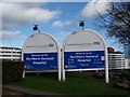
5
Northern General Hospital, Sheffield - 2
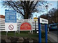
More signs at the Herries Road entrance to the Hospital ... Herries Road Drive is an internal road within the Hospital grounds. You will be pleased to know that there are Accident & Emergency facilities for Children in Sheffield ... they are at the dedicated Sheffield Children's Hospital near to the City Centre.
Image: © Terry Robinson
Taken: 16 Nov 2008
0.13 miles
6
Oakwood Young People's Centre, Sheffield
This facility, opened in 1981, is situated in the grounds of the Northern General Hospital ... this view, of the main entrance, is taken from Car Park H which was empty because it was a Sunday!
Image: © Terry Robinson
Taken: 30 Nov 2008
0.14 miles
7
Herries Road Lodge, Northern General Hospital, Sheffield
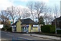
This building near to the Herries Road entrance was originally a Security Lodge where visitors would report. Note the Hospital Sign in the side wall. When it was no longer required for security one half was used as a Flower Shop and (I think) the other half for Newspapers and General Goods useful for visitors to buy for patients. Currently it is disused and 'To Let.' The house partly seen on the left is described in a separate picture. Image Image
Image: © Terry Robinson
Taken: 16 Nov 2008
0.14 miles
8
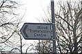
Blood Transfusion Service, Longley Lane, Sheffield
It is many years since the National Blood Service was known as the Blood Transfusion Centre ... but this sign on Herries Road still points the way ... and the general public still know what it mean! Image
Image: © Terry Robinson
Taken: 30 Nov 2008
0.14 miles
10
Northern General Hospital, Sheffield - 1
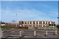
The Northern General Hospital, in Sheffield is huge and has many buildings scattered across the site ... and a number of entrances ... this one for vehicles and pedestrians is on Herries Road. A further entrance for vehicles is on Barnsley Road. A (now) pedestrian only entrance - and the original one to the Sheffield Union Workhouse which evolved into the Hospital - is at Fir Vale. Image
Image: © Terry Robinson
Taken: 16 Nov 2008
0.14 miles