IMAGES TAKEN NEAR TO
Cammell Road, SHEFFIELD, S5 6UU
Introduction
This page details the photographs taken nearby to Cammell Road, S5 6UU by members of the Geograph project.
The Geograph project started in 2005 with the aim of publishing, organising and preserving representative images for every square kilometre of Great Britain, Ireland and the Isle of Man.

There are currently over 7.5m images from over14,400 individuals and you can help contribute to the project by visiting https://www.geograph.org.uk
Image Map
Images are licensed for reuse under creativecommons.org/licenses/by-sa/2.0
Notes
- Clicking on the map will re-center to the selected point.
- The higher the marker number, the further away the image location is from the centre of the postcode.
Image Listing (39 Images Found)
Images are licensed for reuse under creativecommons.org/licenses/by-sa/2.0
Image
Details
Distance
1
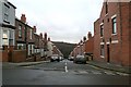
Addison Road
The most southerly of three roads which run straight up the hill to the west of Firth Park Road. The northern side consists of a single Victorian terrace. The southern side has mid-twentieth century semis
Image: © David Lally
Taken: 2 Jan 2010
0.05 miles
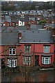
2
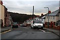
Hamilton Road
Hamilton Road is the middle one of three roads which run straight up the hill to the west of Firth Park Road. If the hill has a name, I don't know it.
The houses on here consist almost entirely of two single terraces, one on each side of the road.
This is looking down the hill from Granby Road which connects the top of the three roads.
Image: © David Lally
Taken: 2 Jan 2010
0.07 miles
3
Vivian Road, from Firth Park
Vivian Road is the northernmost of three roads that climb the hill to the west of Firth Park Road. Of the three it has the best quality of housing, consisting of three-storey villas, with an excellent view of the park.
Image: © David Lally
Taken: 2 Jan 2010
0.09 miles
4
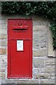
Victorian Post Box
This quite large Victorian Post Box is at the junction of Bolsover Rd and Firth Park Road.
It looks like the wall has been rebuilt quite recently - or maybe it has just been cleaned
Image: © David Lally
Taken: 7 Oct 2007
0.10 miles
5
Bolsover Road
Looking from Granby Road on the hill to the east. The red car passing across the frame is on Barnsley Road (the A6135), behind that lies the Northern General Hospital.
I can vaguely remember when the Northern General was formed by the amalgamation of the Northern Infirmary and City General in the mid-sixties.
Image: © David Lally
Taken: 2 Jan 2010
0.11 miles
6
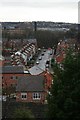
Roofscape
Looking west from Granby Road we look over Cammell Road, Vickers Road (just visible) then Ellerton Road and Wheldrake Road. The final roof ridges just visible before we see the Northern General Hospital are the houses on the east side of Barnsley Road (the A6135).
Image: © David Lally
Taken: 2 Jan 2010
0.11 miles
7
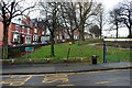
Vivian Road, Firth Park and bus stop
Vivian Road consists of Victorian villas overlooking the south end of Firth Park.
Image: © David Lally
Taken: 2 Jan 2010
0.12 miles
8
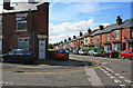
The junction of Vickers and Cammell Roads
Both names referencing steel-based engineering.
The property labelled with the no 95 was once the essential neighbourhood corner shop. In this case "Mrs Holmes's". Many an errand was run to here!
Image: © David Lally
Taken: 15 Jul 2012
0.13 miles
9
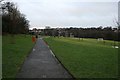
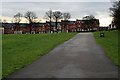
Path along "the top of the park"
That's how we would refer to the grassed area which forms the eastern section of the main part of Firth Park. To the left is a steep wooded valley formed by a small (as far as I know unnamed) stream.
The hill behind is dominated by Image
Image: © David Lally
Taken: 2 Jan 2010
0.13 miles
10
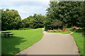
Firth Park
From near to the Cammell Road entrance.
Image: © David Lally
Taken: 25 Aug 2008
0.14 miles