IMAGES TAKEN NEAR TO
Keepers Close, SHEFFIELD, S5 6EF
Introduction
This page details the photographs taken nearby to Keepers Close, S5 6EF by members of the Geograph project.
The Geograph project started in 2005 with the aim of publishing, organising and preserving representative images for every square kilometre of Great Britain, Ireland and the Isle of Man.

There are currently over 7.5m images from over14,400 individuals and you can help contribute to the project by visiting https://www.geograph.org.uk
Image Map
Images are licensed for reuse under creativecommons.org/licenses/by-sa/2.0
Notes
- Clicking on the map will re-center to the selected point.
- The higher the marker number, the further away the image location is from the centre of the postcode.
Image Listing (26 Images Found)
Images are licensed for reuse under creativecommons.org/licenses/by-sa/2.0
Image
Details
Distance
1

Entry to housing units off Bellhouse Road
The last time I came this way (about 35 years ago) a Co-op dairy stood here, from whence milk floats would radiate each morning.
Image: © David Lally
Taken: 2 Jan 2010
0.09 miles
2
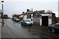
Tiny car repair shop on Windmill Lane
Presumably the message on the shutter is quite recent.
Image: © David Lally
Taken: 2 Jan 2010
0.11 miles
3
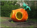
The Sun Apple
The Sun Apple sculpture on the corner of Sicey Avenue and Fairthorne Road, Firth Park, Sheffield.
Image: © Dave Pickersgill
Taken: 16 May 2012
0.11 miles
4

Hartley House Social Club
Once thriving working men's club on Bellhouse Road. Looks to have fallen on hard times. The sign shows two brewery logos from the past, on the left the Stone's cannon and on the right, mostly hidden under the "Car Park at the rear" sign a Ward's wheat sheaf.
Image: © David Lally
Taken: 2 Jan 2010
0.12 miles
5

Striking Bollard on Hatfield House Lane
This lifelike bollard stands opposite Hatfield Primary School. A novel approach to traffic calming and a clever idea.
Image: © Jonathan Clitheroe
Taken: 13 Dec 2011
0.16 miles
6
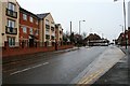
Apartments on Bellhouse Road
At the junction with Hatfield House Lane. Once a Stone's pub called The Horseshoe stood here. The main scene of my under-age drinking of Holstein Pils.
Image: © David Lally
Taken: 2 Jan 2010
0.17 miles
7
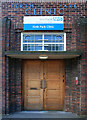
Doorway to the Firth Park Clinic
I think it may have been purpose-built in the early days of the health service as a pre and post natal clinic.
Image: © David Lally
Taken: 15 Jul 2012
0.18 miles
8

Traffic lights on Shiregreen Lane
Junction with Bellhouse Road.
Image: © JThomas
Taken: 27 Sep 2014
0.19 miles
9
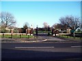
Entrance to Concord Park
Gated entrance to the park situated on Shiregreen Lane.
Image: © Jonathan Clitheroe
Taken: 13 Dec 2011
0.19 miles
10
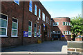
Firth Park Clinic
Still an NHS clinic. I think it may have been purpose-built in the early days of the health service as a pre and post natal clinic.
Image: © David Lally
Taken: 15 Jul 2012
0.19 miles