IMAGES TAKEN NEAR TO
Bellhouse Road, SHEFFIELD, S5 0RB
Introduction
This page details the photographs taken nearby to Bellhouse Road, S5 0RB by members of the Geograph project.
The Geograph project started in 2005 with the aim of publishing, organising and preserving representative images for every square kilometre of Great Britain, Ireland and the Isle of Man.

There are currently over 7.5m images from over14,400 individuals and you can help contribute to the project by visiting https://www.geograph.org.uk
Image Map (Loading...)


Getting Data...Please wait
Leaflet Map data © OpenStreetMap
Images are licensed for reuse under creativecommons.org/licenses/by-sa/2.0
Notes
- Clicking on the map will re-center to the selected point.
- The higher the marker number, the further away the image location is from the centre of the postcode.
Image Listing (5 Images Found)
Images are licensed for reuse under creativecommons.org/licenses/by-sa/2.0
Image
Details
Distance
1
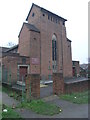
St James and St Christopher
This church in Shiregreen is dedicated to both St James and St Christopher.
Image: © Michael Patterson
Taken: 18 Dec 2006
0.08 miles
2
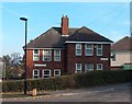
Mason Lathe Road and Oaks Fold corner, Shiregreen
Image: © Neil Theasby
Taken: 24 Oct 2011
0.08 miles
4
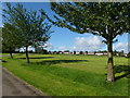
Concord Park
Public park in north Sheffield. Looking towards the Shiregreen housing estate, some of whose residents are fortunate to have the park as their back garden.
Image: © Graham Hogg
Taken: 28 Aug 2012
0.22 miles
