IMAGES TAKEN NEAR TO
Barnsley Road, SHEFFIELD, S5 0QN
Introduction
This page details the photographs taken nearby to Barnsley Road, S5 0QN by members of the Geograph project.
The Geograph project started in 2005 with the aim of publishing, organising and preserving representative images for every square kilometre of Great Britain, Ireland and the Isle of Man.

There are currently over 7.5m images from over14,400 individuals and you can help contribute to the project by visiting https://www.geograph.org.uk
Image Map
Images are licensed for reuse under creativecommons.org/licenses/by-sa/2.0
Notes
- Clicking on the map will re-center to the selected point.
- The higher the marker number, the further away the image location is from the centre of the postcode.
Image Listing (19 Images Found)
Images are licensed for reuse under creativecommons.org/licenses/by-sa/2.0
Image
Details
Distance
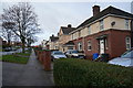
2
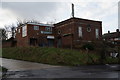
Former Phoenix Social Club on Deerlands Avenue
Image: © Ian S
Taken: 17 Dec 2014
0.06 miles
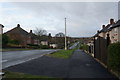
3
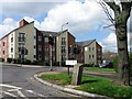
The Huntsman housing development
The Huntsman housing development at the junction of Deerlands Avenue and Barnsley Road. It occupies the site of the former Huntsman public house.
Image: © Martin Speck
Taken: 21 Apr 2010
0.07 miles
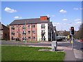
4
Barnsley Road and Deerlands Avenue
Barnsley road crosses Hartley Brook Road (right) and Deerlands Avenue (left). To the left beyond the traffic lights is the site of the demolished Huntsman public house. This land has since been developed as a small high density housing estate called Huntsman. Image
Image: © Martin Speck
Taken: 17 Jul 2007
0.08 miles
5
Trans Pennine Trail, Hartley Brook Road, Shiregreen
Image: © Ian S
Taken: 17 Dec 2014
0.09 miles
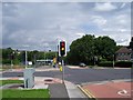
7
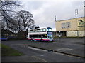
Bus at Sheffield Lane Top terminus
The huge turning circle off Barnsley Road at Sheffield Lane Top is, as far as I know, not currently used, but when this photograph was taken the 75 from Batemoor via Sheffield city centre terminated here. The bus in the picture will have entered the turning circle to the photographer's left and passed the parked car on the extreme left to reach the bus stop; I presume the section of pavement between the photographer and the bus was once the site of a second bus stop to allow two routes to use the turning circle without impeding one another.
Image: © Richard Vince
Taken: 5 Dec 2009
0.12 miles

10
Trans Pennine Trail, Molineaux Road, Shiregreen
Image: © Ian S
Taken: 17 Dec 2014
0.15 miles