IMAGES TAKEN NEAR TO
Bland Street, SHEFFIELD, S4 8DG
Introduction
This page details the photographs taken nearby to Bland Street, S4 8DG by members of the Geograph project.
The Geograph project started in 2005 with the aim of publishing, organising and preserving representative images for every square kilometre of Great Britain, Ireland and the Isle of Man.

There are currently over 7.5m images from over14,400 individuals and you can help contribute to the project by visiting https://www.geograph.org.uk
Image Map (Loading...)


Getting Data...Please wait
Leaflet Map data © OpenStreetMap
Images are licensed for reuse under creativecommons.org/licenses/by-sa/2.0
Notes
- Clicking on the map will re-center to the selected point.
- The higher the marker number, the further away the image location is from the centre of the postcode.
Image Listing (17 Images Found)
Images are licensed for reuse under creativecommons.org/licenses/by-sa/2.0
Image
Details
Distance
2
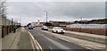
Carlisle Street East, Sheffield
An area known as Brightside
Image: © Chris Morgan
Taken: 2 Jan 2020
0.11 miles
4
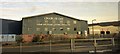
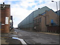
Steel cutting firm, Grimesthorpe
The premises of Charles Day, "a specialist profiling and cutting operation" seen from a train of the railway line between Sheffield and Rotherham, as betrayed by the dirt on the window. This is on Downgate Drive, a small road housing a number of engineering works.
Image: © Derek Harper
Taken: 6 Apr 2012
0.12 miles
5
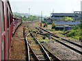
Taking on water
46790 Leander hauling the Coast to Coast Express is here stopped in a siding in Brightside to take on water
Image: © Graham Hogg
Taken: 19 May 2018
0.16 miles
6
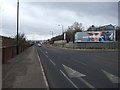
Sheffield: B6082 Carlisle Street East, Brightside
A long straight road through an industrial area, this image was taken at the junction with Atlas Street.
Image: © Nigel Cox
Taken: 25 Feb 2007
0.22 miles
7
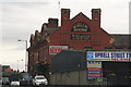
The Ball Inn, and the Upwell Street Tyre and Auto Centre
See also Image from 2010.
Three years later the pub is still open, though with a different advertisement on the wall.
Image: © Chris
Taken: 22 Apr 2013
0.22 miles
8
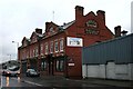
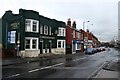
The Ball Inn, Upwell Street
Substantial pub with signs for the long-defunct Bentley's brewery of Rotherham. It was a Stone's pub in my youth. I do not know what part of the building now houses the boxing centre.
Image: © David Lally
Taken: 2 Jan 2010
0.22 miles
9
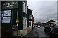
The Sheffield Arms, Upwell Street
A former Ward's pub displaying, appropriately, the Sheffield coat-of-arms as its sign.
Image: © David Lally
Taken: 2 Jan 2010
0.23 miles
10
The Sheffield Arms, Upwell Street
A former Ward's pub displaying, appropriately, the Sheffield coat-of-arms as its sign.
Image: © David Lally
Taken: 2 Jan 2010
0.23 miles