IMAGES TAKEN NEAR TO
Brathay Close, SHEFFIELD, S4 8BQ
Introduction
This page details the photographs taken nearby to Brathay Close, S4 8BQ by members of the Geograph project.
The Geograph project started in 2005 with the aim of publishing, organising and preserving representative images for every square kilometre of Great Britain, Ireland and the Isle of Man.

There are currently over 7.5m images from over14,400 individuals and you can help contribute to the project by visiting https://www.geograph.org.uk
Image Map
Images are licensed for reuse under creativecommons.org/licenses/by-sa/2.0
Notes
- Clicking on the map will re-center to the selected point.
- The higher the marker number, the further away the image location is from the centre of the postcode.
Image Listing (20 Images Found)
Images are licensed for reuse under creativecommons.org/licenses/by-sa/2.0
Image
Details
Distance
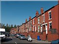
4
Sheffield: Birdwell Road, Grimesthorpe
Typical terraced housing of the area.
Image: © Nigel Cox
Taken: 25 Feb 2007
0.14 miles
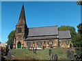
5
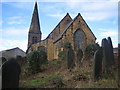
Sheffield: St Thomas, Brightside
Completed in 1854 and made redundant by the Diocese of Sheffield in 1979.
Image: © Nigel Cox
Taken: 25 Feb 2007
0.14 miles
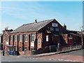
6
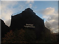
Sheffield Forgemasters (1)
One of the few steelworks left in the Sheffield area, once known the world over for its steel.
Image: © Stephen Craven
Taken: 5 Nov 2016
0.17 miles
7
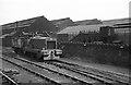
Locomotive at River Don Works, Sheffield
Number unidentified, it is one of a batch of 10 built for the English Steel Corporation in 1959 for use at the River Don site.
The precise location of the site can be identified on old OS maps from the track layout and the fact that it is passing over a weighbridge. The weighbridge house still survives – here a very small corner of it can be seen to the left of the loco cab.
Image: © Alan Murray-Rust
Taken: 20 Apr 1965
0.17 miles
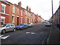
10
Holywell Heights
Holywell Heights, a new housing development.
Image: © Martin Speck
Taken: 19 Jul 2009
0.18 miles