IMAGES TAKEN NEAR TO
Effingham Road, SHEFFIELD, S4 7YT
Introduction
This page details the photographs taken nearby to Effingham Road, S4 7YT by members of the Geograph project.
The Geograph project started in 2005 with the aim of publishing, organising and preserving representative images for every square kilometre of Great Britain, Ireland and the Isle of Man.

There are currently over 7.5m images from over14,400 individuals and you can help contribute to the project by visiting https://www.geograph.org.uk
Image Map (Loading...)


Getting Data...Please wait
Leaflet Map data © OpenStreetMap
Images are licensed for reuse under creativecommons.org/licenses/by-sa/2.0
Notes
- Clicking on the map will re-center to the selected point.
- The higher the marker number, the further away the image location is from the centre of the postcode.
Image Listing (125 Images Found)
Images are licensed for reuse under creativecommons.org/licenses/by-sa/2.0
Image
Details
Distance
1

Motor spares business by the canal
The canal is The Sheffield & Tinsley Canal and the business is called "JST Motor Spares" on Effingham Road.
Image: © Neil Theasby
Taken: 30 Sep 2019
0.02 miles
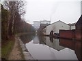
2
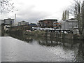
Mixed industry between the canal and Effingham Road
Image: © Robin Stott
Taken: 3 Apr 2012
0.02 miles
3

Cygnet on the Canal
A cygnet on the Sheffield Canal, December 2011. Sheffield Canal runs 3.9 miles (6.3 km) from Tinsley, where it leaves the River Don, to the Sheffield Canal Basin (now Victoria Quays), passing through 11 locks.
Image: © Dave Pickersgill
Taken: 15 Dec 2011
0.02 miles
4
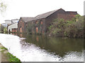
Dilley & Sons Warehouse
Road access to this building is from Effingham Road; but it obviously used to have access by water too. It is grade 2 listed (List Entry Number 1270724). From the list description, it was originally built for the Firth family, steel makers, and used for the storage of bar iron from Sweden before it was processed in the cementation and crucible works. It is said to be the sole survivor of this type of warehouse in Sheffield.
Image: © Stephen Craven
Taken: 3 Apr 2012
0.04 miles
5
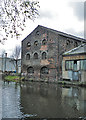
Canalside Warehouse
Or perhaps it might have been a factory. Whatever it was, it has seen better days.
Image: © Anne Burgess
Taken: 3 Apr 2012
0.04 miles


8
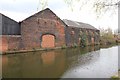
Sheffield and Tinsley Canal
Iron Wharf, once used by Thos. Firth & sons to unload Swedish iron. The former wharf, now a factory unit off the B6071 Effingham Road, and the canal in front of it, are in the very NW corner of this grid square. Taken during the Geograph Conference 2012 first guided walk.
Image: © David P Howard
Taken: 3 Apr 2012
0.05 miles
9

Sheffield and Tinsley Canal
The canal just cuts across the NW corner of this grid square, and about 60 metres of the tow path from this point is in the square. Taken during the Geograph Conference 2012 first guided walk.
Image: © David P Howard
Taken: 3 Apr 2012
0.05 miles
10
The Tinsley Canal
The canal just cuts across the north west corner of this gridsquare between Lumley Street and Effingham Road. The completion of the canal in 1819 realised a long-held ambition to connect Sheffield with the rivers Trent and Humber but as with many of the canal systems, its viability was quickly threatened by the arrival of the railways. Commercial traffic did however continue to operate on the canal until as late as the early 1970s.
Image: © Jonathan Clitheroe
Taken: 21 Feb 2011
0.06 miles