IMAGES TAKEN NEAR TO
Atlas Way, SHEFFIELD, S4 7QQ
Introduction
This page details the photographs taken nearby to Atlas Way, S4 7QQ by members of the Geograph project.
The Geograph project started in 2005 with the aim of publishing, organising and preserving representative images for every square kilometre of Great Britain, Ireland and the Isle of Man.

There are currently over 7.5m images from over14,400 individuals and you can help contribute to the project by visiting https://www.geograph.org.uk
Image Map
Images are licensed for reuse under creativecommons.org/licenses/by-sa/2.0
Notes
- Clicking on the map will re-center to the selected point.
- The higher the marker number, the further away the image location is from the centre of the postcode.
Image Listing (56 Images Found)
Images are licensed for reuse under creativecommons.org/licenses/by-sa/2.0
Image
Details
Distance
1
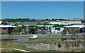
Brightside Lane
The A6109 uses Brightside Lane in this area.
Image: © Mary and Angus Hogg
Taken: 29 Jun 2018
0.08 miles
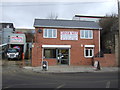
3
Fancy a drink?
Le Bon Vin on Brightside Lane Sheffield.
Image: © Steve Fareham
Taken: 16 Aug 2008
0.11 miles
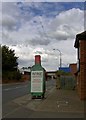
4
Brightside Lane passing under the railway bridge
Image: © Colin Pyle
Taken: 7 Apr 2019
0.12 miles
7
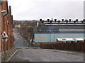
Attercliffe - Carwood Road / Carlisle Road junction
Image: © Dave Bevis
Taken: 28 Feb 2009
0.15 miles
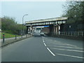
8
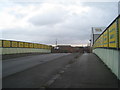
Former railway bridge
This takes Carwood Road over the course of the former railway which formed the first rail route into Sheffield form the north. It was opened in 1838 by the Sheffield and Rotherham Railway and ran to a terminus which was later known as Wicker station. This closed to passengers in 1870 being replaced by Sheffield Midland station. However Wicker had continued use as a goods depot until 1965.
Apart from this bridge nearly all evidence of the existence of a railway here has been obliterated.
Image: © Jonathan Thacker
Taken: 15 Dec 2012
0.16 miles
10
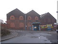
Carwood Park
A misleading title for factory units situated in old industrial buildings.
Image: © Jonathan Thacker
Taken: 15 Dec 2012
0.17 miles