IMAGES TAKEN NEAR TO
Earldom Road, SHEFFIELD, S4 7EJ
Introduction
This page details the photographs taken nearby to Earldom Road, S4 7EJ by members of the Geograph project.
The Geograph project started in 2005 with the aim of publishing, organising and preserving representative images for every square kilometre of Great Britain, Ireland and the Isle of Man.

There are currently over 7.5m images from over14,400 individuals and you can help contribute to the project by visiting https://www.geograph.org.uk
Image Map
Images are licensed for reuse under creativecommons.org/licenses/by-sa/2.0
Notes
- Clicking on the map will re-center to the selected point.
- The higher the marker number, the further away the image location is from the centre of the postcode.
Image Listing (15 Images Found)
Images are licensed for reuse under creativecommons.org/licenses/by-sa/2.0
Image
Details
Distance
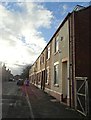
1
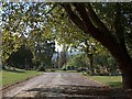
Burngreave Cemetery
Taken from a first floor window overlooking the cemetery on the north side
Image: © Debbie Herring
Taken: 21 Dec 2005
0.09 miles
3
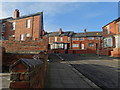
Looking up Ella Street to Malton St, Pitsmoor
Image: © Neil Theasby
Taken: 8 Jan 2016
0.16 miles
4
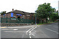
Sikh Temple in Grimesthorpe
I have no idea what the original purpose of this building was (though it may well have been some form of place of worship).
Throughout most of the 1970's it was utilised as the dining room of De La Salle College, a Catholic grant maintained grammar school which stood about half a mile away on Scott Road.
Image: © David Lally
Taken: 14 Jun 2008
0.16 miles
5
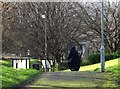
Woman on a path at Burngreave
This area of Sheffield is perhaps the most ethnically diverse so it was no surprise to see a Muslim woman walking home through Ellesmere Park.
Image: © Neil Theasby
Taken: 8 Jan 2016
0.17 miles
6
Demolition of All Saints, Brightside, Sheffield
A comment made by a previous contributor for this square was of an old black church that once stood on the site. This photograph was taken during 1977 while the church of All Saints, Brightside (also referred to as All Saints, Pitsmoor) was being demolished. A brave bell-hanger had ascended the half-demolished church to rescue the ring of eight bells; the bells now ring out from St Anne's church, Worksop.The day and month are a guess but the year is accurate.
Image: © Dave Kelly
Taken: 23 Aug 1977
0.17 miles
7
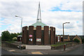
Church on Lyons Street
The opposite view of Image
In the 1970s when I would go for school dinners in the building seen in the above link, there stood on this site a large Victorian Gothic church. As with all the building of that age in Sheffield at that time it was black from years of domestic and industrial air pollution.
Image: © David Lally
Taken: 14 Jun 2008
0.17 miles
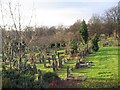
8
In Burngreave/Pitsmoor Cemetery, Sheffield
Image: © Neil Theasby
Taken: 15 Sep 2011
0.17 miles
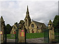
9
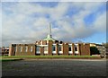
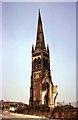
St Peter's Church, Ellesmere, Sheffield
St Peter's Ellesmere was opened on Easter Sunday, 1980. It stands on the site of the former All Saints Anglican Church which was demolished, due to a faulty structure, in the late 1970s. It was a joint church building, also involving the former Petre Street Methodist Church which was demolished under a Compulsory Purchase Order when Sheffield Council began to redevelop the Ellesmere and Carwood Estates.
Image: © Neil Theasby
Taken: 8 Jan 2016
0.18 miles