IMAGES TAKEN NEAR TO
Firshill Crescent, SHEFFIELD, S4 7DJ
Introduction
This page details the photographs taken nearby to Firshill Crescent, S4 7DJ by members of the Geograph project.
The Geograph project started in 2005 with the aim of publishing, organising and preserving representative images for every square kilometre of Great Britain, Ireland and the Isle of Man.

There are currently over 7.5m images from over14,400 individuals and you can help contribute to the project by visiting https://www.geograph.org.uk
Image Map (Loading...)


Getting Data...Please wait
Leaflet Map data © OpenStreetMap
Images are licensed for reuse under creativecommons.org/licenses/by-sa/2.0
Notes
- Clicking on the map will re-center to the selected point.
- The higher the marker number, the further away the image location is from the centre of the postcode.
Image Listing (7 Images Found)
Images are licensed for reuse under creativecommons.org/licenses/by-sa/2.0
Image
Details
Distance
1
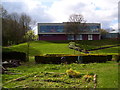
Sheaf Training
This is Sheffield City Council's Employment Unit which offers training in a number of subjects, including horticulture.
Image: © Martin Speck
Taken: 15 Apr 2012
0.11 miles
2

Sheffield United training ground
The hallamfm academy, the training ground of Sheffield United F.C.
Image: © Dave Pickersgill
Taken: 12 Jul 2004
0.12 miles
3
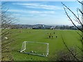
Sheffield United FC Training Ground
An unusually large level site in this hilly part of Sheffield.
Image: © Graham Hogg
Taken: 1 Mar 2012
0.18 miles
4

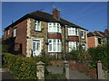
Shirecliffe Road
The aftermath of a traffic accident on Shirecliffe Road.
Image: © Martin Speck
Taken: 8 May 2011
0.21 miles
7
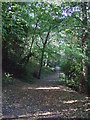
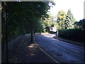
Track into Little Roe Wood
Off Norwood Road.
Image: © JThomas
Taken: 27 Sep 2014
0.25 miles