IMAGES TAKEN NEAR TO
Wylam Close, CHESTERFIELD, S45 9TL
Introduction
This page details the photographs taken nearby to Wylam Close, S45 9TL by members of the Geograph project.
The Geograph project started in 2005 with the aim of publishing, organising and preserving representative images for every square kilometre of Great Britain, Ireland and the Isle of Man.

There are currently over 7.5m images from over14,400 individuals and you can help contribute to the project by visiting https://www.geograph.org.uk
Image Map
Images are licensed for reuse under creativecommons.org/licenses/by-sa/2.0
Notes
- Clicking on the map will re-center to the selected point.
- The higher the marker number, the further away the image location is from the centre of the postcode.
Image Listing (13 Images Found)
Images are licensed for reuse under creativecommons.org/licenses/by-sa/2.0
Image
Details
Distance
1
Clay Cross - Coronation Club
On Stollard Street.
Image: © Dave Bevis
Taken: 2 Nov 2011
0.14 miles
2
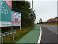
Coney Green Road, Clay Cross
Green being for cycles.
Image: © Peter Barr
Taken: 8 Sep 2010
0.18 miles
3
Clay Cross - Entrance to Coney Green Farm
Image: © Alan Heardman
Taken: 5 Feb 2009
0.19 miles
4
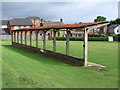
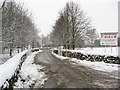
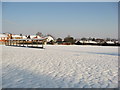
Clay Cross - spectator stand in Sharley Park
The football pitch has long gone, but the spectator stand remains. An alternative (winter) view is at Image
Image: © Dave Bevis
Taken: 11 Jun 2010
0.19 miles
5
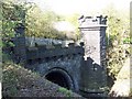
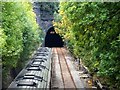
Clay Cross Tunnel
This is Clay Cross Tunnel which is of Moorish design and grade 2 listed. The tunnel was completed in 1839 by George Stephenson and is 1,784 yards long and Clay Cross High Street is 150 feet above the line. The tunnel eventually cost £140,000 instead of £98,000 with the loss of 15 lives. As the tunnel was bored out they found coal and iron in large amounts and so George Stephenson opened the Clay Cross Company.
Image: © Tony Hawes
Taken: 18 Apr 2007
0.20 miles
7
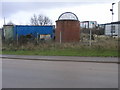
Tunnel Vent
This vent is for the railway tunnel on the Midland Mainline between Derby and Chesterfield. An industrial estate is built around the vent.
Image: © Michael Patterson
Taken: 28 Mar 2006
0.20 miles
9
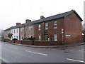
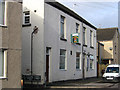
Clay Cross - Gaffers Row
“Gaffers’ Row”, or more correctly Egstow Terrace, was built in 1846 and is now the only surviving example of early employees’ housing by the Clay Cross Company. Of better than average standard of their time, they were built for the foreman grades. Despite external alterations in recent years, these houses, on Market Street, have retained much of their distinctive character. See http://users.breathe.com/claycrosschurch/town/Clay%20Cross%20trail.pdf.
Image: © Dave Bevis
Taken: 12 Jan 2011
0.21 miles