IMAGES TAKEN NEAR TO
Rock Crescent, CHESTERFIELD, S45 9QT
Introduction
This page details the photographs taken nearby to Rock Crescent, S45 9QT by members of the Geograph project.
The Geograph project started in 2005 with the aim of publishing, organising and preserving representative images for every square kilometre of Great Britain, Ireland and the Isle of Man.

There are currently over 7.5m images from over14,400 individuals and you can help contribute to the project by visiting https://www.geograph.org.uk
Image Map
Images are licensed for reuse under creativecommons.org/licenses/by-sa/2.0
Notes
- Clicking on the map will re-center to the selected point.
- The higher the marker number, the further away the image location is from the centre of the postcode.
Image Listing (8 Images Found)
Images are licensed for reuse under creativecommons.org/licenses/by-sa/2.0
Image
Details
Distance
3
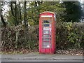
Telephone Box
Old style telephone box which looks in urgent need of some TLC.
Image: © Tony Bacon
Taken: 17 Nov 2011
0.20 miles
5
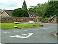
Boat Display
Colourful flower display inside a rowing boat.
Image: © Tony Bacon
Taken: 29 Jul 2017
0.23 miles
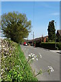
6
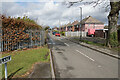
Coupe Lane
The road marks the upper edge of the Holmgate housing estate.
Image: © Bill Boaden
Taken: 7 Apr 2022
0.24 miles
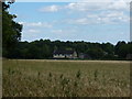
7
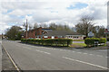
Holmgate Evangelical Church
Right on the edge of Clay Cross, the church is affiliated to the FIEC.
Image: © Bill Boaden
Taken: 7 Apr 2022
0.25 miles
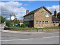
8
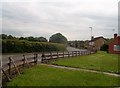
Coupe Lane in Woodthorpe
The Woodthorpe Inn can also be seen here on the right of picture.
Image: © Jonathan Clitheroe
Taken: 31 May 2014
0.25 miles