IMAGES TAKEN NEAR TO
Derwent Place, CHESTERFIELD, S45 9PS
Introduction
This page details the photographs taken nearby to Derwent Place, S45 9PS by members of the Geograph project.
The Geograph project started in 2005 with the aim of publishing, organising and preserving representative images for every square kilometre of Great Britain, Ireland and the Isle of Man.

There are currently over 7.5m images from over14,400 individuals and you can help contribute to the project by visiting https://www.geograph.org.uk
Image Map
Images are licensed for reuse under creativecommons.org/licenses/by-sa/2.0
Notes
- Clicking on the map will re-center to the selected point.
- The higher the marker number, the further away the image location is from the centre of the postcode.
Image Listing (7 Images Found)
Images are licensed for reuse under creativecommons.org/licenses/by-sa/2.0
Image
Details
Distance
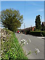
4
Coupe Lane in Woodthorpe
The Woodthorpe Inn can also be seen here on the right of picture.
Image: © Jonathan Clitheroe
Taken: 31 May 2014
0.17 miles
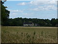
5
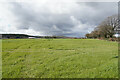
Field above Coupe Lane
The view from the houses on the eastern side of Coupe Lane, looking up towards Woodthorpe Grange and Stone Edge.
Image: © Bill Boaden
Taken: 7 Apr 2022
0.19 miles
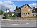
6
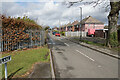
Coupe Lane
The road marks the upper edge of the Holmgate housing estate.
Image: © Bill Boaden
Taken: 7 Apr 2022
0.25 miles
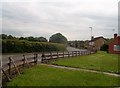
7
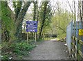
Entrance to Tupton Wood
Southern entrance to Far Tupton Wood, with Electricity sub-station on the right, taken from Woodlands Way.
Image: © Tony Bacon
Taken: 15 Apr 2007
0.25 miles