IMAGES TAKEN NEAR TO
Elm Grove, CHESTERFIELD, S45 9LA
Introduction
This page details the photographs taken nearby to Elm Grove, S45 9LA by members of the Geograph project.
The Geograph project started in 2005 with the aim of publishing, organising and preserving representative images for every square kilometre of Great Britain, Ireland and the Isle of Man.

There are currently over 7.5m images from over14,400 individuals and you can help contribute to the project by visiting https://www.geograph.org.uk
Image Map
Images are licensed for reuse under creativecommons.org/licenses/by-sa/2.0
Notes
- Clicking on the map will re-center to the selected point.
- The higher the marker number, the further away the image location is from the centre of the postcode.
Image Listing (71 Images Found)
Images are licensed for reuse under creativecommons.org/licenses/by-sa/2.0
Image
Details
Distance
1
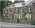
Clay Cross - Market Street Nos 115 to 123
For an alternative view of this terrace, please see Image
Image: © Dave Bevis
Taken: 22 Jul 2015
0.04 miles
2
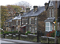
Clay Cross - Market Street Nos 97 to 125
Image: © Dave Bevis
Taken: 14 Nov 2010
0.04 miles
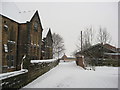
3
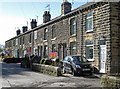
Clay Cross - Hall Terrace
Off Market Street.
Image: © Dave Bevis
Taken: 26 Apr 2015
0.04 miles
4
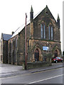
Clay Cross - Free Methodist Chapel
Dated 1887.
Image: © Dave Bevis
Taken: 14 Nov 2010
0.05 miles
6
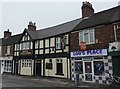
Shop, Pub, Take-away
On Market Street, Clay Cross.
Image: © Peter Barr
Taken: 8 Sep 2010
0.05 miles
7
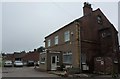
Coach booking office
With geese statuary on porch roof, Market Street, Clay Cross
Image: © Peter Barr
Taken: 8 Sep 2010
0.05 miles
8
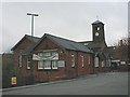
Adult Education Centre and Clock Tower
Clay Cross
Image: © Alan Heardman
Taken: 24 Apr 2000
0.06 miles
10
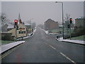
Clay Cross Traffic Lights
A61 from Stretton side of Lights
Image: © Alan Heardman
Taken: 21 Jan 2001
0.06 miles