IMAGES TAKEN NEAR TO
Coney Green Road, CHESTERFIELD, S45 9HZ
Introduction
This page details the photographs taken nearby to Coney Green Road, S45 9HZ by members of the Geograph project.
The Geograph project started in 2005 with the aim of publishing, organising and preserving representative images for every square kilometre of Great Britain, Ireland and the Isle of Man.

There are currently over 7.5m images from over14,400 individuals and you can help contribute to the project by visiting https://www.geograph.org.uk
Image Map
Images are licensed for reuse under creativecommons.org/licenses/by-sa/2.0
Notes
- Clicking on the map will re-center to the selected point.
- The higher the marker number, the further away the image location is from the centre of the postcode.
Image Listing (53 Images Found)
Images are licensed for reuse under creativecommons.org/licenses/by-sa/2.0
Image
Details
Distance
1
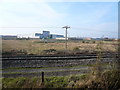
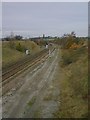
North Wingfield Nature Reserve View
Looking across the railway line to Coney Green.
Image: © Alan Heardman
Taken: 4 Nov 2007
0.01 miles
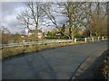
2

Frosty View from Pilsley Road towards Clay Cross Hall
Image: © Alan Heardman
Taken: 22 Dec 2006
0.04 miles
3
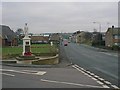
Danesmoor War Memorial
Guildford Lane and Pilsley Road Junction
Image: © Alan Heardman
Taken: 2 Jan 2000
0.04 miles
4
Danesmoor Railway Bridge
Looking Towards Hagg Hill
Image: © Alan Heardman
Taken: 21 Nov 1999
0.04 miles
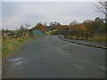
7
Danesmoor - River Rother Passes Under Railway
View from Pit Lane towards Berts Plant
Image: © Alan Heardman
Taken: 20 Feb 2000
0.04 miles
8
Danesmoor - Railway Bridge view to North Wingfield Church
Image: © Alan Heardman
Taken: 21 Nov 1999
0.04 miles
9
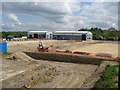
Danesmoor - View towards Coney Green Development
Image: © Alan Heardman
Taken: 31 Jul 2007
0.05 miles
10
Danesmoor - Industrial Unit Development (Mayfield View)
Image: © Alan Heardman
Taken: 18 May 2008
0.06 miles