IMAGES TAKEN NEAR TO
Flaxpiece Road, CHESTERFIELD, S45 9HD
Introduction
This page details the photographs taken nearby to Flaxpiece Road, S45 9HD by members of the Geograph project.
The Geograph project started in 2005 with the aim of publishing, organising and preserving representative images for every square kilometre of Great Britain, Ireland and the Isle of Man.

There are currently over 7.5m images from over14,400 individuals and you can help contribute to the project by visiting https://www.geograph.org.uk
Image Map
Images are licensed for reuse under creativecommons.org/licenses/by-sa/2.0
Notes
- Clicking on the map will re-center to the selected point.
- The higher the marker number, the further away the image location is from the centre of the postcode.
Image Listing (30 Images Found)
Images are licensed for reuse under creativecommons.org/licenses/by-sa/2.0
Image
Details
Distance
1
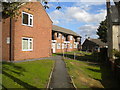
Low rise flats off Flaxpiece Road, Clay Cross
Pedestrian access provided by a footpath.
Image: © Richard Vince
Taken: 13 Oct 2018
0.01 miles
2
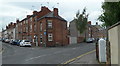
Junction of Flaxpiece Road and Commonpiece Road
Traditional terraced houses in Clay Cross.
Image: © Andrew Hill
Taken: 27 May 2011
0.08 miles
3
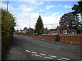
South end of Flaxpiece Road, Clay Cross
Seen from Springvale Road, with Cemetery Road to the right.
Image: © Richard Vince
Taken: 13 Oct 2018
0.09 miles
4
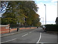
West end of Cemetery Road, Clay Cross
Seen from the junction with Springvale Road. The cemetery is behind the wall and railings on the left.
Image: © Richard Vince
Taken: 13 Oct 2018
0.10 miles
5
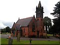
Chapel and Memorial at Clay Cross Cemetery
The monument in front of the chapel commemorates the loss of 45 lives in an explosion at Park House Pit in 1882.
Image: © Jonathan Clitheroe
Taken: 26 Sep 2012
0.13 miles
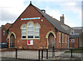
6
Clay Cross - Catholic Church
On Thanet Street. Dedicated to Saints Patrick and Bridget.
Image: © Dave Bevis
Taken: 5 Apr 2013
0.13 miles
7
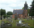
Cemetery and chapel by Cemetery Road
The cemetery is found between the communities of Clay Cross and Danesmoor.
Image: © Andrew Hill
Taken: 27 May 2011
0.13 miles
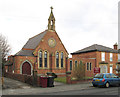
8
Clay Cross - Salvation Army citadel
On Thanet Street.
Image: © Dave Bevis
Taken: 5 Apr 2013
0.14 miles
9
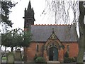
Danesmoor - Clay Cross Cemetery Chapel
This photo depicts the porch to the east chapel. Other photos on Geograph by Alan Heardman eg Image focus on the monument to the south of the chapel.
Image: © Dave Bevis
Taken: 13 Mar 2009
0.14 miles
10
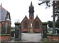
Danesmoor - Cemetery Gates, Memorial and Chapel
For more info about the Parkhouse Colliery disaster and the memorial in front of the chapel in Danesmoor Cemetery, see http://www.claycross.org.uk/No7Parkhouse/No7Parkhouse.htm
Image: © Dave Bevis
Taken: 13 Mar 2009
0.14 miles