IMAGES TAKEN NEAR TO
High Street, CHESTERFIELD, S45 9DZ
Introduction
This page details the photographs taken nearby to High Street, S45 9DZ by members of the Geograph project.
The Geograph project started in 2005 with the aim of publishing, organising and preserving representative images for every square kilometre of Great Britain, Ireland and the Isle of Man.

There are currently over 7.5m images from over14,400 individuals and you can help contribute to the project by visiting https://www.geograph.org.uk
Image Map
Images are licensed for reuse under creativecommons.org/licenses/by-sa/2.0
Notes
- Clicking on the map will re-center to the selected point.
- The higher the marker number, the further away the image location is from the centre of the postcode.
Image Listing (114 Images Found)
Images are licensed for reuse under creativecommons.org/licenses/by-sa/2.0
Image
Details
Distance
1
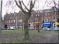
Old Victoria Hotel and Victoria shop buildings
The building with the archway up to the tree was the Victoria Hotel built in 1876; the rest are six three-storied shops known as the Victoria Buildings which was built at the same time as the hotel.
Image: © Tony Hawes
Taken: 31 Jan 2007
0.01 miles
2
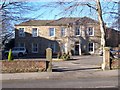
Hill House, Clay Cross
Hill House residential home, I have been told this is the oldest building in Clay Cross if anyone knows the date it was built please let me know. Hill House is situated in between Clay Cross Church and the old Victoria Hotel on High St Clay Cross.
Image: © Tony Hawes
Taken: 5 Feb 2007
0.01 miles
3
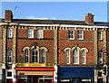
Clay Cross - Victoria Buildings
For a wider view of these buildings, please see Image
Image: © Dave Bevis
Taken: 22 Jan 2012
0.02 miles
4
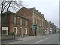
Clay Cross - High Street (Victoria Buildings)
Image: © Alan Heardman
Taken: 24 Apr 2000
0.02 miles
5
Cock Alley
Another view of Image looking East towards Clay Cross High Street.
Image: © Tony Bacon
Taken: 31 Jul 2007
0.02 miles
6
Clay Cross - Viewed from Newmarket Lane
Image: © Alan Heardman
Taken: 19 Jan 2007
0.02 miles
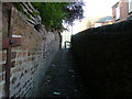
7
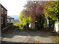
Public footpath west of Clay Cross (1)
Sneaking between two driveways as it heads down the hillside from the edge of the town centre.
Image: © Richard Vince
Taken: 13 Oct 2018
0.03 miles
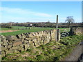
8
St.Bartholomew's
Parish church on the A61 at Clay Cross
Image: © Roger May
Taken: 5 Dec 2005
0.04 miles
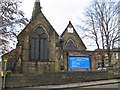
9
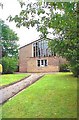
Clay Cross, Derbyshire, the Methodist Church
The Methodist Church is situated on the East side of the A61, almost directly opposite to St Bartholomew's Church.
Image: © Bill Henderson
Taken: Unknown
0.04 miles
10
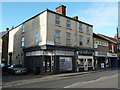
Corner Building
Building on the High Street, Clay Cross, which used to be The Westminster Bank in the 1940's until moving directly opposite into larger premises, probably in the 1950's. It now houses an Estate Agents.
Image: © Tony Bacon
Taken: 15 Feb 2012
0.04 miles