IMAGES TAKEN NEAR TO
The Square, CHESTERFIELD, S45 9BZ
Introduction
This page details the photographs taken nearby to The Square, S45 9BZ by members of the Geograph project.
The Geograph project started in 2005 with the aim of publishing, organising and preserving representative images for every square kilometre of Great Britain, Ireland and the Isle of Man.

There are currently over 7.5m images from over14,400 individuals and you can help contribute to the project by visiting https://www.geograph.org.uk
Image Map
Images are licensed for reuse under creativecommons.org/licenses/by-sa/2.0
Notes
- Clicking on the map will re-center to the selected point.
- The higher the marker number, the further away the image location is from the centre of the postcode.
Image Listing (65 Images Found)
Images are licensed for reuse under creativecommons.org/licenses/by-sa/2.0
Image
Details
Distance
2

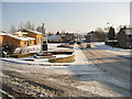
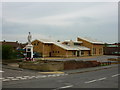
Danesmoor - Junction of Church Avenue with Pilsley Road
Construction of new church can be seen in the background.
Image: © Alan Heardman
Taken: 14 Mar 2007
0.04 miles
3
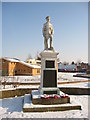
Danesmoor - War Memorial and St. Barnabas Centre
Image: © Alan Heardman
Taken: 3 Feb 2009
0.04 miles
4
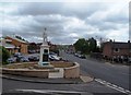
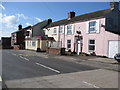
Pilsley Road in Danesmoor
As well as the war memorial in the foreground, the Barnabas Centre can also be seen on the left of picture plus the village post office which is situated among the block of terraced houses on the right of the road.
Image: © Jonathan Clitheroe
Taken: 10 May 2014
0.05 miles

7
Danesmoor - The Greyhound Public House
Image: © Alan Heardman
Taken: 30 Mar 2008
0.06 miles
8
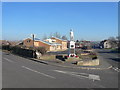
Danesmoor - Guildford Lane Junction with Pilsley Road
This view clearly shows the War Memorial, and the new St.Barnabas' Centre which was officially opened on the 9th of November 2007.
Image: © Alan Heardman
Taken: 11 Feb 2008
0.06 miles
9
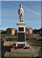
Danesmoor - War Memorial and St. Barnabas Centre
Views of the original church which stood on the site of the new Centre, its subsequent demolition, and various stages in the construction of the new building shown here, are well documented on the Geograph site, many by contributor Alan Heardman.
Image: © Gordon Elliott
Taken: 28 Apr 2010
0.06 miles
10
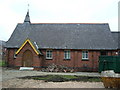
St Barnabas Church, Danesmoor
Small church prior to demolition in January 2007.
Image: © Tony Bacon
Taken: 28 Jan 2007
0.06 miles