IMAGES TAKEN NEAR TO
Guildford Close, CHESTERFIELD, S45 9BE
Introduction
This page details the photographs taken nearby to Guildford Close, S45 9BE by members of the Geograph project.
The Geograph project started in 2005 with the aim of publishing, organising and preserving representative images for every square kilometre of Great Britain, Ireland and the Isle of Man.

There are currently over 7.5m images from over14,400 individuals and you can help contribute to the project by visiting https://www.geograph.org.uk
Image Map
Images are licensed for reuse under creativecommons.org/licenses/by-sa/2.0
Notes
- Clicking on the map will re-center to the selected point.
- The higher the marker number, the further away the image location is from the centre of the postcode.
Image Listing (71 Images Found)
Images are licensed for reuse under creativecommons.org/licenses/by-sa/2.0
Image
Details
Distance
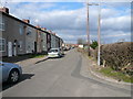
2
Danesmoor - Guildford Lane
View from Welfare (High Flat).
Image: © Alan Heardman
Taken: 2 Mar 2007
0.04 miles
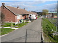
3
Danesmoor - Allotments off Guildford Lane
Image: © Alan Heardman
Taken: 14 Mar 2007
0.06 miles
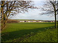
5
Danesmoor - Cricket Pavilion
Situated next to the Clay Cross & Danesmoor Miners Welfare on the edge of the High Flat sports ground where championship cycle races were once held.
Image: © Alan Heardman
Taken: 3 Feb 2009
0.11 miles
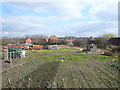
6
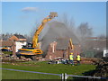
Danesmoor - St Barnabas Church Demolition
Image: © Alan Heardman
Taken: 6 Feb 2007
0.11 miles
7
Danesmoor - Construction of New Church
Image: © Alan Heardman
Taken: 14 Mar 2007
0.12 miles
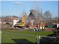
9
Danesmoor - St Barnabas Church Demolition
Image: © Alan Heardman
Taken: 6 Feb 2007
0.12 miles
10
Danesmoor - St Barnabas Church Demolition
Image: © Alan Heardman
Taken: 6 Feb 2007
0.12 miles