IMAGES TAKEN NEAR TO
Holmgate Road, CHESTERFIELD, S45 9BA
Introduction
This page details the photographs taken nearby to Holmgate Road, S45 9BA by members of the Geograph project.
The Geograph project started in 2005 with the aim of publishing, organising and preserving representative images for every square kilometre of Great Britain, Ireland and the Isle of Man.

There are currently over 7.5m images from over14,400 individuals and you can help contribute to the project by visiting https://www.geograph.org.uk
Image Map
Images are licensed for reuse under creativecommons.org/licenses/by-sa/2.0
Notes
- Clicking on the map will re-center to the selected point.
- The higher the marker number, the further away the image location is from the centre of the postcode.
Image Listing (5 Images Found)
Images are licensed for reuse under creativecommons.org/licenses/by-sa/2.0
Image
Details
Distance
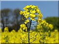
2
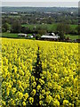
Path to Hollis Farm, Holmgate
Through a field of blooming rape.
Image: © Neil Theasby
Taken: 3 May 2014
0.15 miles
3
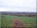
Fields and Public Footpath overlooking Clay Cross
This picture was taken from a ridge of high ground close to Broomy Wood.
Image: © Jonathan Clitheroe
Taken: 3 Jan 2011
0.19 miles
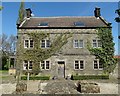
4
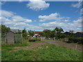
Poplar Farm, Henmoor
Near Clay Cross, Derbyshire.
Image: © Peter Barr
Taken: 10 Aug 2010
0.19 miles