IMAGES TAKEN NEAR TO
Woodhead Lane, CHESTERFIELD, S45 9AY
Introduction
This page details the photographs taken nearby to Woodhead Lane, S45 9AY by members of the Geograph project.
The Geograph project started in 2005 with the aim of publishing, organising and preserving representative images for every square kilometre of Great Britain, Ireland and the Isle of Man.

There are currently over 7.5m images from over14,400 individuals and you can help contribute to the project by visiting https://www.geograph.org.uk
Image Map
Images are licensed for reuse under creativecommons.org/licenses/by-sa/2.0
Notes
- Clicking on the map will re-center to the selected point.
- The higher the marker number, the further away the image location is from the centre of the postcode.
Image Listing (8 Images Found)
Images are licensed for reuse under creativecommons.org/licenses/by-sa/2.0
Image
Details
Distance
1
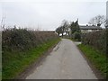
Woodhead Lane - Approaching Deerleap Cottages
Image: © Alan Heardman
Taken: 23 Mar 2007
0.01 miles
2

Old School House at Junction of Deerleap Lane and Woodhead Lane
Image: © Alan Heardman
Taken: 22 Mar 2007
0.03 miles
3
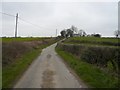
Woodhead Lane
View towards Deerleap Cottages.
Image: © Alan Heardman
Taken: 23 Mar 2007
0.04 miles
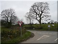
4
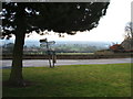
Signposts, green and conifer
Littlemoor, looking towards Clay Cross
Image: © Peter Barr
Taken: 19 Feb 2009
0.06 miles
6
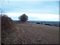
Public Footpath near Littlemoor
Public footpath following a ridge over arable land near Littlemoor.
Image: © Jonathan Clitheroe
Taken: 3 Jan 2011
0.17 miles
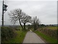
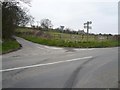
7
Deerleap Lane - Junction with Ashover Road
Image: © Alan Heardman
Taken: 23 Mar 2007
0.23 miles
8
Stoney Lane - Viewed from Deerleap Lane
Image: © Alan Heardman
Taken: 23 Mar 2007
0.25 miles