IMAGES TAKEN NEAR TO
Stretton Road, CHESTERFIELD, S45 9AQ
Introduction
This page details the photographs taken nearby to Stretton Road, S45 9AQ by members of the Geograph project.
The Geograph project started in 2005 with the aim of publishing, organising and preserving representative images for every square kilometre of Great Britain, Ireland and the Isle of Man.

There are currently over 7.5m images from over14,400 individuals and you can help contribute to the project by visiting https://www.geograph.org.uk
Image Map
Images are licensed for reuse under creativecommons.org/licenses/by-sa/2.0
Notes
- Clicking on the map will re-center to the selected point.
- The higher the marker number, the further away the image location is from the centre of the postcode.
Image Listing (17 Images Found)
Images are licensed for reuse under creativecommons.org/licenses/by-sa/2.0
Image
Details
Distance
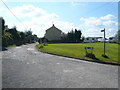
1
Clowns Children's Centre in Clay Cross
Image: © Neil Theasby
Taken: 19 Nov 2017
0.18 miles
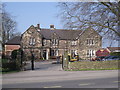
3
Clowns Day Nursery
High Street, Clay Cross.
Image: © Peter Barr
Taken: 10 Aug 2010
0.20 miles
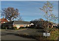
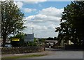
5
Parkhouse Pit Explosion Monument
Sited in Danesmoor Cemetery
Image: © Alan Heardman
Taken: 24 Apr 2000
0.20 miles
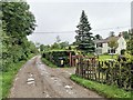
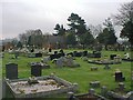
6
Parkhouse Pit Explosion Monument
Commemoration
Image: © Alan Heardman
Taken: 24 Apr 2000
0.20 miles
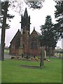
7
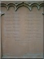
Parkhouse Pit Explosion Monument
Their Names
Image: © Alan Heardman
Taken: 24 Apr 2000
0.20 miles
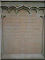
8
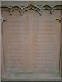
Parkhouse Pit Explosion Monument
Their Names
Image: © Alan Heardman
Taken: 24 Apr 2000
0.20 miles