IMAGES TAKEN NEAR TO
Newmarket Lane, CHESTERFIELD, S45 9AP
Introduction
This page details the photographs taken nearby to Newmarket Lane, S45 9AP by members of the Geograph project.
The Geograph project started in 2005 with the aim of publishing, organising and preserving representative images for every square kilometre of Great Britain, Ireland and the Isle of Man.

There are currently over 7.5m images from over14,400 individuals and you can help contribute to the project by visiting https://www.geograph.org.uk
Image Map
Images are licensed for reuse under creativecommons.org/licenses/by-sa/2.0
Notes
- Clicking on the map will re-center to the selected point.
- The higher the marker number, the further away the image location is from the centre of the postcode.
Image Listing (9 Images Found)
Images are licensed for reuse under creativecommons.org/licenses/by-sa/2.0
Image
Details
Distance
1
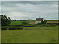
House by Newmarket Lane
The path I wanted is not clearly signed, and I was on the wrong side of the hedge on the left and had to return to the corner. All would have been well if I had got a 1:25,000 on the ground.
Image: © Andrew Hill
Taken: 27 Jun 2012
0.11 miles
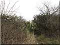
4
Country stile
With the ubiquitous style of the nearby town in the discarded Coca Cola can!
Image: © Chris Morgan
Taken: 24 Feb 2014
0.16 miles
5
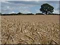
In a barley field
Near Clay Cross, Derbyshire.
Image: © Peter Barr
Taken: 10 Aug 2010
0.17 miles
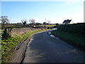
6
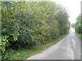
Newmarket Lane
This view is in the direction of Newmarket Farm. The shrubs on the left side of the road have many sloe bushes.
Image: © Alan Heardman
Taken: 28 Sep 2007
0.18 miles
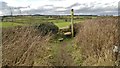
7
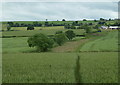
Path to Stretton Hall Farm
The ground rises towards Littlemoor on the right skyline.
Image: © Andrew Hill
Taken: 27 Jun 2012
0.18 miles
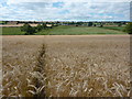
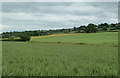
9
Open wheat field between Clay Cross and Handley
View from the path east of Stretton Hall Farm.
Image: © Andrew Hill
Taken: 27 Jun 2012
0.21 miles