IMAGES TAKEN NEAR TO
Broom Avenue, CHESTERFIELD, S45 8HP
Introduction
This page details the photographs taken nearby to Broom Avenue, S45 8HP by members of the Geograph project.
The Geograph project started in 2005 with the aim of publishing, organising and preserving representative images for every square kilometre of Great Britain, Ireland and the Isle of Man.

There are currently over 7.5m images from over14,400 individuals and you can help contribute to the project by visiting https://www.geograph.org.uk
Image Map
Images are licensed for reuse under creativecommons.org/licenses/by-sa/2.0
Notes
- Clicking on the map will re-center to the selected point.
- The higher the marker number, the further away the image location is from the centre of the postcode.
Image Listing (98 Images Found)
Images are licensed for reuse under creativecommons.org/licenses/by-sa/2.0
Image
Details
Distance
1
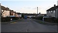
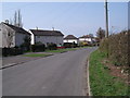
Broom Avenue
This photograph shows Broom Avenue at its junction with Hallgate Lane, which is running across the foreground of the picture.
To see a photograph of Hallgate Lane to the left of this picture, click here Image
To see a photograph of Hallgate Lane to the right of this picture, click here Image
The houses are prefabricated and were built after the Second World War to house an increase in the mining workforce. Some of these houses have been purchased by their tenants and modernised (note the ones to the left that have been externally clad).
The road joining from the right, in the middle of the picture is Image
In the centre of the photograph, in front of the houses facing, Broom Avenue follows an ‘S-bend' to the right and then left before it continues to its junction with Pear Tree Road and Queensway.
To see a more southerly (ahead) view of Broom Avenue beyond the 'S-bend', click here Image
To the left of the houses facing there is a public Image that links Broom Avenue with Crow Croft Road.
Image: © Alan Walker
Taken: 22 Jan 2007
0.02 miles
2
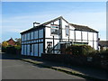
Tudor beam style house
House in a Tudor Beam style, which looks strangely out of place amongst the council properties on the estate.
Image: © Tony Bacon
Taken: 21 Oct 2007
0.03 miles
3
Crow Croft Road, Pilsley
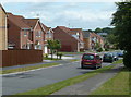
View down the street of modern houses, seen from Hallgate Lane.
Image: © Andrew Hill
Taken: 27 May 2011
0.04 miles
4
Hallgate Lane
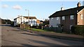
The photograph shows Hallgate Lane looking toward its junction with Rupert Street and Bridge Street and was taken from the lane’s junction with Image
For a view of Hallgate Lane, from beyond the black and white house, back toward this viewpoint, click here Image
For a more east north-easterly (onward) photograph of Hallgate Lane, click here Image
For a more westerly (behind the viewpoint) photograph of Hallgate Lane, click here Image
Image: © Alan Walker
Taken: 22 Jan 2007
0.04 miles
5
Footpath
Image: © Alan Walker
Taken: 1 Feb 2007
0.04 miles
6
Lonsdale Road
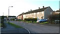
Lonsdale Road is a cul-de-sac off Image
See also this photograph by Tony Bacon, Image, which was taken from Lonsdale Road.
Image: © Alan Walker
Taken: 22 Jan 2007
0.06 miles
7
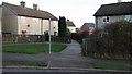
Footpath
This footpath links the northern end of Image with Image
To see the other end of the footpath, click here Image
To see a more southerly (off the right hand side of the photograph) view of Broom Avenue beyond the 'S-bend', click here Image
Image: © Alan Walker
Taken: 22 Jan 2007
0.06 miles
8
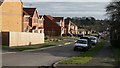
Crow Croft Road
This photograph of Crow Croft Road is taken from its junction with Image
In the middle of the photograph, coming in from the left is Image
To see a more southerly (ahead) photograph of Crow Croft Road, click here Image
See also this photograph by Andrew Hill: Image
Image: © Alan Walker
Taken: 12 Jan 2007
0.06 miles