IMAGES TAKEN NEAR TO
Rother Street, CHESTERFIELD, S45 8HG
Introduction
This page details the photographs taken nearby to Rother Street, S45 8HG by members of the Geograph project.
The Geograph project started in 2005 with the aim of publishing, organising and preserving representative images for every square kilometre of Great Britain, Ireland and the Isle of Man.

There are currently over 7.5m images from over14,400 individuals and you can help contribute to the project by visiting https://www.geograph.org.uk
Image Map
Images are licensed for reuse under creativecommons.org/licenses/by-sa/2.0
Notes
- Clicking on the map will re-center to the selected point.
- The higher the marker number, the further away the image location is from the centre of the postcode.
Image Listing (161 Images Found)
Images are licensed for reuse under creativecommons.org/licenses/by-sa/2.0
Image
Details
Distance
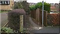
1
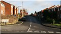
Forest Drive
This photograph shows Forest Drive from its junction with Bridge Street Image In the centre of the picture the road turns to the left where it junctions with Slack’s Lane Image The houses date from the 1970’s.
Behind the viewpoint is the entrance to Grange Farm Image and also the site of the "Town's Pump" or the "Rother Spring Pump."
Image: © Alan Walker
Taken: 10 Jan 2007
0.02 miles
2
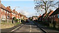
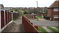
Rother Street
The photograph shows the cul-de-sac, Rother Street. The houses on either side of the street were all social housing although a number have been, subsequently, purchased by their tenants. The houses at the end of Rother Street are in Warren Close where there is a short footpath joining the two Image
The photograph was taken from Bridge Street Image
* * *
See also this photograph by Andrew Hill: Image
Image: © Alan Walker
Taken: 10 Jan 2007
0.02 miles
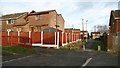
3
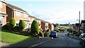
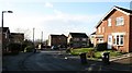
The Paddocks
This road is part of a small estate built by Barratt Homes in the late 1970's, early 1980's. See also image Image
Approximately 50metres behind the viewpoint The Paddocks has junctions with Image and Image
Image: © Alan Walker
Taken: 10 Jan 2007
0.02 miles
4
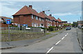
Rother Street, Pilsley
A short residential street off the main road through the village. No doubt named with regard to the source of the River Rother being in fields close by.
Image: © Andrew Hill
Taken: 27 May 2011
0.02 miles
5
Footpath
Before more modern housing was built the left-hand side of this photograph was a field and the path ran down its edge. This path was one of those that the miners would have used on their way to the colliery entrance. Today the path runs to Image via Rother Street and a children’s playing field.
To see a more southerly (ahead) view of this footpath at its junction with Rother Street, click here: Image
Click here Image for a view of Slack's Lane taken from the same viewpoint.
Image: © Alan Walker
Taken: 11 Jan 2007
0.03 miles
6
Footpath
This short footpath (going forward into the photograph) links Rother Street (behind the viewpoint) Image to Warren Close Image The houses in the distance are in The Paddocks Image
There is also a Image crossing the photograph from side to side. On the left the footpath leads to Slack’s Lane Image On the right it leads to a children’s playing field and then on Image towards Station Road.
Image: © Alan Walker
Taken: 12 Jan 2007
0.05 miles
7
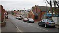
Bridge Street
This photograph was taken from the most southerly end of Bridge Street by the corner of the Image
On the right can be seen the Image and the Image
For a photograph looking back to this viewpoint from about 75 metres north, click here Image
Image: © Alan Walker
Taken: 15 Jan 2007
0.05 miles
8
Bridge Street
Bridge Street near its junction with Image
Click here Image for a more northerly view of Bridge Street.
Click here Image for a more southerly view of Bridge Street.
Image: © Alan Walker
Taken: 11 Jan 2007
0.05 miles
9
Footpath
This footpath runs from Image (behind the viewpoint) to Station Road (the row of houses running left to right in the distance).
At this point the footpath crosses the end of Rother Street where a short footpath joins (the left of the photograph) from Image
To the south (ahead) the footpath can be seen entering, and running down the side of, a field. The field is Sampsonfield, a children's playing area. To see a photograph of the field, click here Image
To see a more northerly (behind the viewpoint) view of this footpath, click here Image
To see a view of this junction from Rother Street, click here Image
Image: © Alan Walker
Taken: 15 Jan 2007
0.05 miles
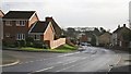
10
Warren Close
This road is part of a small estate built by Barratt Homes in the late 1970's, early 1980's. It is a cul-de-sac leading off Image
At the end of Warren Close there is a short Image linking the close with Rother Street.
Image: © Alan Walker
Taken: 10 Jan 2007
0.05 miles