IMAGES TAKEN NEAR TO
Bridge Street, CHESTERFIELD, S45 8HE
Introduction
This page details the photographs taken nearby to Bridge Street, S45 8HE by members of the Geograph project.
The Geograph project started in 2005 with the aim of publishing, organising and preserving representative images for every square kilometre of Great Britain, Ireland and the Isle of Man.

There are currently over 7.5m images from over14,400 individuals and you can help contribute to the project by visiting https://www.geograph.org.uk
Image Map
Images are licensed for reuse under creativecommons.org/licenses/by-sa/2.0
Notes
- Clicking on the map will re-center to the selected point.
- The higher the marker number, the further away the image location is from the centre of the postcode.
Image Listing (185 Images Found)
Images are licensed for reuse under creativecommons.org/licenses/by-sa/2.0
Image
Details
Distance
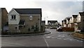
1
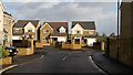
Bridge Street from Reeves Avenue
Bridge Street Image from Reeves Avenue. The houses 'across the road' in Bridge Street plus those in Reeves Avenue are all part of the same development that was constructed in the early years of the twenty first century.
The site had been derelict for some years having been the former site of 'Reeve Burgess' a local engineering company that built small 'city style' buses, ambulances, etc. Reeves Burgess, in its latter years, was owned by Plaxtons, the coachbuilders near Scarborough. The parent company closed Reeve Burgess and moved the production to Scarborough.
A few metres behind the viewpoint is the Junction of Peak Close with Reeves Avenue Image
To see a photograph in the opposite direction from Bridge Street into Reeves Avenue, click here Image
Web links for Reeve Burgess:
Wikipedia : http://en.wikipedia.org/wiki/Reeve_Burgess
Hansard : http://www.publications.parliament.uk/pa/cm199091/cmhansrd/1991-04-25/Debate-1.html
Hansard : http://www.parliament.the-stationery-office.co.uk/pa/cm199091/cmhansrd/1991-05-13/Debate-1.html
Image: © Alan Walker
Taken: 11 Jan 2007
0.02 miles
2
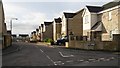
Reeves Avenue
Reeves Avenue from Bridge Street Image The houses in Reeves Avenue are all part of a development constructed in the early years of the twenty first century. Peak Close is also part of the same development Image
To see a photograph in the opposite direction from Reeves Avenue to Bridge Street, click here Image
Image: © Alan Walker
Taken: 12 Jan 2007
0.03 miles
3
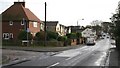
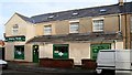
Bridge Street
Bridge Street near its junction with Image on the left and Image (just seen) on the right.
Click here Image for a more northerly view of Bridge Street.
Click here Image for a more southerly view of Bridge Street.
Image: © Alan Walker
Taken: 11 Jan 2007
0.04 miles
4
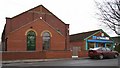
Bridge Street Evangelical Methodist Church
Image: © Alan Walker
Taken: 15 Jan 2007
0.04 miles
5
Pilsley News
Pilsley News, on Bridge Street, describes itself as an ‘Off Licence’ and ‘Convenience Grocers.’ Amongst other commodities it sells, foodstuffs, newspapers and magazines, gift-wrapping, gas & electric cards, greetings cards and electronic phone top-ups.
To see a photograph of the store’s location in Bridge Street, click here Image
Click one of these to see other shops in Pilsley:
Image
Image
Image
Image
Image
Image
Image: © Alan Walker
Taken: 12 Jan 2007
0.04 miles
6
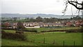
View across fields
This view across fields is from Image and is looking towards a Image and the rear of houses on Bridge Street.
Click to see a photograph of the front of the houses on Image
The slight depression running through the fields in the centre of the photograph becomes the source of the River Rother. To see a photograph looking back, from the playing field toward this area, click here Image
Image: © Alan Walker
Taken: 15 Jan 2007
0.04 miles
8
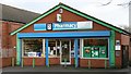
Co-op Pharmacy
The local pharmacy. This building is on the site of what was once the village cinema and is situated on Image near to Image and the Image GP’s Practice.
The larger building to the left is the Image
Click one of these to see other shops in Pilsley:
Image
Image
Image
Image
Image
Image
Image: © Alan Walker
Taken: 11 Jan 2007
0.04 miles
9
Peak Close from Reeves Avenue
The photograph shows the junction of Peak Close with Reeves Avenue Image Both roads have the same basic layout, that of a letter ‘L’ where the long side runs approximately east to west before turning southerly into the short side that terminates with a turning area.
Image: © Alan Walker
Taken: 11 Jan 2007
0.05 miles
10
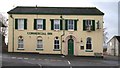
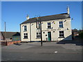
Commercial Inn
The Commercial Inn is the first building at the northern end of Church Street. From the right-hand side of the building (note the Image) the road becomes the southern end of Image
The photograph was taken from the small cul-de-sac of Image
The inn was built in the nineteenth century by a John Brocksop. Originally the building had three floors but the top one was removed as a result of storm damage in the 1960’s. The Commercial Inn is very close to another public house, the Willow Tree Inn. In recent years these two premises have struggled to remain viable and both have been closed, on and off, for months at a time.
Other public house in Pilsley are Image and the Image
To see a photograph that shows the rear of the building, click here Image
Image: © Alan Walker
Taken: 11 Jan 2007
0.05 miles