IMAGES TAKEN NEAR TO
Station Road, CHESTERFIELD, S45 8BN
Introduction
This page details the photographs taken nearby to Station Road, S45 8BN by members of the Geograph project.
The Geograph project started in 2005 with the aim of publishing, organising and preserving representative images for every square kilometre of Great Britain, Ireland and the Isle of Man.

There are currently over 7.5m images from over14,400 individuals and you can help contribute to the project by visiting https://www.geograph.org.uk
Image Map
Images are licensed for reuse under creativecommons.org/licenses/by-sa/2.0
Notes
- Clicking on the map will re-center to the selected point.
- The higher the marker number, the further away the image location is from the centre of the postcode.
Image Listing (124 Images Found)
Images are licensed for reuse under creativecommons.org/licenses/by-sa/2.0
Image
Details
Distance
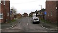
1
Manor Close
Manor Close from its junction with Image
Image: © Alan Walker
Taken: 15 Jan 2007
0.01 miles
2
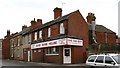
Sang Sang House
The Sang Sang House sells 'take-away' Chinese food and is situated on Image
Click one of these to see other shops in Pilsley:
Image
Image
Image
Image
Image
Image
Image: © Alan Walker
Taken: 15 Jan 2007
0.03 miles
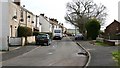
3
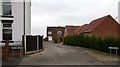
Manor Farm
The photograph shows the junction of the cul-de-sac, Manor Farm, with Image
Image: © Alan Walker
Taken: 15 Jan 2007
0.04 miles
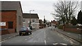
4
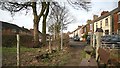
Station Road
On the left of the photograph is a wall, facing, in front of which the end of a gravel path can just be made out. This Image runs north from Station Road to Image
The Image sells 'take-away' Chinese Food.
On the right of the photograph, in front of the pebble-dashed wall is the junction with the cul-de-sac, Image
Behind the viewpoint, and to the left, is a junction with Image
Behind the viewpoint, and to the right, is a junction with the cul-de-sac, Image
For a more north-easterly view (ahead) of Station Road, click here Image
For a more south-westerly view (behind the viewpoint) of Station Road, click here Image
Image: © Alan Walker
Taken: 15 Jan 2007
0.04 miles
5
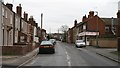
Rouse Street
The photograph shows the cul-de-sac, Rouse Street from its junction with Image
For a more south-easterly (ahead) photograph of the street, click here Image
Image: © Alan Walker
Taken: 15 Jan 2007
0.06 miles
6
Rouse Street
The photograph shows Rouse Street.
For a more south-easterly (ahead) photograph of the street, click here Image
For a more north-westerly (behind the viewpoint) photograph of Rouse Street taken from its junction with Image, click here Image
Image: © Alan Walker
Taken: 13 Feb 2007
0.07 miles
7
Station Road
Station Road from its junction with Image (behind the viewpoint) and Image to the left of the photograph.
The wall on the right is the boundary wall with Image At the end of this wall is the junction with Image
The wall on the left is the boundary with the Image
The tall building on the left used to be the Wesleyan Methodist church hall and schoolroom but in 1995 the main church building was found to be unsafe. Consequently the church building was demolished and the church hall and schoolroom now act as the church proper. Beyond this building is the junction with Image
For a more north-easterly view (ahead) of Station Road, click here Image
Image: © Alan Walker
Taken: 15 Jan 2007
0.07 miles
8
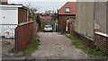
Footpath
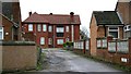
The photograph shows the junction of the footpath that runs south from Image to this point on Image For the first few metres the path shares a drive with the house, right of centre, in the middle distance and beyond a gateway to a field.
For a more northerly view of this footpath click here Image
Image: © Alan Walker
Taken: 15 Jan 2007
0.07 miles
9
Rouse Street
The photograph, taken from the Pilsley end of a footpath from Tibshelf shows the south-eastern end of Rouse Street.
On the north-eastern side of the street the houses are older than those on the opposite side.
For a photograph taken from near this viewpoint but looking in the opposite direction, click here Image
For a more north-westerly (ahead) photograph of Rouse Street, but looking back, toward this viewpoint, click here Image
For a more south-easterly (behind the viewpoint) photograph of the footpath, click here Image
Image: © Alan Walker
Taken: 13 Feb 2007
0.08 miles
10

View across fields
Taken from Image this photograph shows the view across fields looking to the backs of house in Image
Image: © Alan Walker
Taken: 15 Jan 2007
0.08 miles