IMAGES TAKEN NEAR TO
Station Road, CHESTERFIELD, S45 8BH
Introduction
This page details the photographs taken nearby to Station Road, S45 8BH by members of the Geograph project.
The Geograph project started in 2005 with the aim of publishing, organising and preserving representative images for every square kilometre of Great Britain, Ireland and the Isle of Man.

There are currently over 7.5m images from over14,400 individuals and you can help contribute to the project by visiting https://www.geograph.org.uk
Image Map
Images are licensed for reuse under creativecommons.org/licenses/by-sa/2.0
Notes
- Clicking on the map will re-center to the selected point.
- The higher the marker number, the further away the image location is from the centre of the postcode.
Image Listing (70 Images Found)
Images are licensed for reuse under creativecommons.org/licenses/by-sa/2.0
Image
Details
Distance
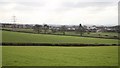
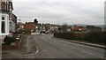
1
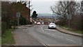
Station Road
The photograph shows Station Road looking in a southwesterly direction toward the village.
Immediately behind the viewpoint is the site of Pilsley railway station and the crossing of the Five Pits Trail.
On the hill, in the extreme distance, it is just possible to make out is Image This landmark, standing at about 1000ft above sea level, is a war memorial. Built in 1923 it is dedicated to the Sherwood Foresters who died in the First World War. Thanks to Millennium Funding a lantern that shines at night ensures that the memorial can be seen from many parts of the village.
For another photograph of Station Road, from the same viewpoint but in the opposite direction, click here Image
For another photograph of Station Road, from a more southwesterly viewpoint (ahead), click here Image
Image: © Alan Walker
Taken: 15 Jan 2007
0.00 miles
2
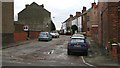
New Street
The photograph shows New Street from its Junction with Image
For another more south-easterly (some 20metres ahead) photograph of New Street, click her Image
Image: © Alan Walker
Taken: 15 Jan 2007
0.02 miles
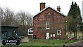
3
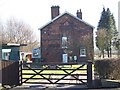
Station master's house, Pilsley
This is the station master's house which once belonged to the Great Central railway, it has long since been sold privately.
The railway station was on the opposite side of the road in a cutting, filled in about ten years after the line closed in 1959. More information about the station and its railway lines at http://www.disused-stations.org.uk/p/pilsley/index.shtml
Image: © Tony Hawes
Taken: 4 Feb 2007
0.03 miles
4
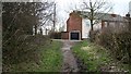
Dark Lane
This photograph shows the view from Dark Lane looking towards its junction with Image
To view another photograph looking back to this viewpoint from Station Road, click here Image
For a more north-westerly (behind the viewpoint) view of the footpath, click here Image
Image: © Alan Walker
Taken: 15 Jan 2007
0.03 miles
5
View over fields
This view over fields toward Image was taken from a footpath that links Image to the Image
The land in the photograph drains into the infant River Rother. To see another photograph of this land but looking eastward (from the right) toward the trees in the middle distance, click here Image
The viewpoint is very nearly the same as that used for this Image, but is looking in approximately the opposite direction.
To see a photograph of the footpath taken some 75metres southwest (right) of this viewpoint, click here Image
Image: © Alan Walker
Taken: 18 Feb 2007
0.03 miles
6
Station Master's House
The photograph shows the gable end of the Pilsley Station Master's house on Image This house was built on land between two railway cuttings containing lines operated by the Great Central Railway.
The plaque (insert, bottom left) is not from that period and is situated on the gate leading to the house.
See also this photograph taken by Tony Hawes, Image
Image: © Alan Walker
Taken: 15 Jan 2007
0.04 miles
7
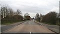
Station Road
The photograph shows the north-eastern end of Station Road from its junction with the Five Pits Trail and Image (behind the viewpoint).
To the right of the photograph in the middle distance is a Image and just beyond that (hidden in this picture) are two plaques commemorating the land reclamation scheme.
To the left there is a car park and the Image continues in a southerly direction toward Tibshelf.
To the right the Image continues in a northerly direction toward Image
For a more south-western (ahead) photograph of Station Road, looking back toward this viewpoint, click here Image
Image: © Alan Walker
Taken: 15 Jan 2007
0.04 miles
8
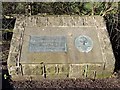
Land Reclamation Scheme plaque
This plaque is dedicated to the Derbyshire County Council Land Reclamation Scheme in 1969-70 showing that this was the site of the former Pilsley Colliery and Great Central Railway, over the road is the station master's house.
Image: © Tony Hawes
Taken: 4 Feb 2007
0.05 miles
9
Station Road
This photograph is of Station Road from its junction with Image
Just beyond the concrete post and barge-board wall (left of centre) is the street's junction with Image
To see another more south-westerly view (ahead) of Station Road, click here Image
To see another from a more north-easterly (behind the viewpoint) view of Station Road, click here Image
Image: © Alan Walker
Taken: 15 Jan 2007
0.05 miles
10
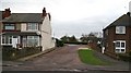
Unnamed Road
This photograph shows the junction of an unnamed road with Image
Image: © Alan Walker
Taken: 15 Jan 2007
0.05 miles