IMAGES TAKEN NEAR TO
Green Lane, CHESTERFIELD, S45 8AR
Introduction
This page details the photographs taken nearby to Green Lane, S45 8AR by members of the Geograph project.
The Geograph project started in 2005 with the aim of publishing, organising and preserving representative images for every square kilometre of Great Britain, Ireland and the Isle of Man.

There are currently over 7.5m images from over14,400 individuals and you can help contribute to the project by visiting https://www.geograph.org.uk
Image Map
Images are licensed for reuse under creativecommons.org/licenses/by-sa/2.0
Notes
- Clicking on the map will re-center to the selected point.
- The higher the marker number, the further away the image location is from the centre of the postcode.
Image Listing (65 Images Found)
Images are licensed for reuse under creativecommons.org/licenses/by-sa/2.0
Image
Details
Distance
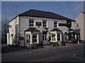
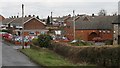
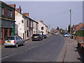
3
Green Lane
The photo shows the western end of Green Lane (ahead) at its junction with Image (foreground).
On the left of the picture is the Image of the Pilsley Congregation Of Jehovah's Witnesses.
Ahead Green Lane continues toward its Image with Locko Lane.
To see a photograph of Green Lane from ahead, near to where it disappears from view, but looking back, toward this viewpoint, click here Image
Image: © Alan Walker
Taken: 18 Feb 2007
0.02 miles
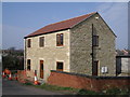
4
Kingdom Hall
The photograph shows the car park and Kingdom Hall of the Pilsley Congregation Of Jehovah's Witnesses.
The car park and building are on the site of the former Rupert Street Methodist Church, 1869-1972.
The location is at the junction of Rupert Street and Image
This photograph was taken from Image
Image: © Alan Walker
Taken: 18 Feb 2007
0.05 miles
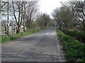
5
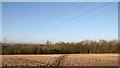
Footpath
The photograph shows a view over fields and a public footpath dropping down toward Image running through the hollow in the middle distance with the line of trees.
From a viewpoint further along the footpath (ahead under the power lines) there is this view of an Image
Some 100metres behind the viewpoint (and taken from approximately the same point as the photograph described next) is this photograph of a Image
Also, some 100metres behind the viewpoint (and taken from approximately the same point as the photograph described previously) is this photograph of a Image looking toward Locko Plantation.
Behind the viewpoint the footpath continues toward Image and Image
Image: © Alan Walker
Taken: 14 Feb 2007
0.06 miles
6
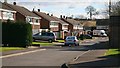
Hazel Avenue
The cul-de-sac, Hazel Avenue, from its junction with Image
Ahead and opposite to where the white van is parked (though not visible in this photograph) are some garages, by the side of which is a short path that links Hazel Avenue to Rupert Street.
The path joins Image opposite the Image
Behind the viewpoint and some 30 metres to the right is Acres Road’s junction with Image
Image: © Alan Walker
Taken: 26 Feb 2007
0.06 miles
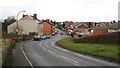
7
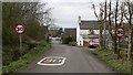
Green Lane
The photograph shows Green Lane as it enters Lower Pilsley. Behind the viewpoint Green Lane continues toward its Image with Locko Lane.
The junction ahead is with Image
To see a photograph of Green Lane from the junction ahead and looking back, toward this viewpoint, click here Image
To see a more easterly (behind the viewpoint) photograph of Green Lane, click here Image
Image: © Alan Walker
Taken: 18 Feb 2007
0.06 miles
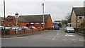
9
Rupert Street
The photograph shows Rupert Street, Lower Pilsley.
The road junction in the middle distance is Rupert Street’s junction with Image
The car park and building on the corner of the junction is the Image of the Pilsley Congregation Of Jehovah's Witnesses.
For a more northerly (ahead) photograph of Rupert Street, click here Image
For a more southerly (behind the viewpoint) photograph of Rupert Street, click here Image
Image: © Alan Walker
Taken: 18 Feb 2007
0.07 miles